Eddies everywhere
Image of the Month - June 2017

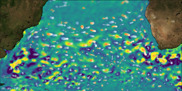
Eddies are ubiquitous in the ocean. They can be quite easily pinpointed in any altimetry map of sea level anomalies but also of absolute dynamic topography. However, they do not appear and disappear at a given location in one day - they are generated by mechanisms such as turbulence, they move around and fade away, with some having lasted more than one year, and traveled thousands of kilimoeters, others no more than a few days and kilometers. They can be tracked and followed day by day for nearly 25 years.
They transport heat(or cold) and salt around, mixing waters between oceans and ocean regions. For example, the Agulhas Current retroflection, when it turns sharply back East, forms eddies (sometimes called "Agulhas rings") which transports warm and salty water from the Indian to the Atlantic Ocean. A steady string of rings is thus escaping from this turn in the currents into the Atlantic, and propagates there.
Altimetry, with now nearly 25 years of data available is providing with long-term, homogenerous, mesoscale sea level anomalies data. This enables to study day to day variations, but also long-term trends in the ocean dynamics.
See also:
- Image of the Month, Sep. 2007: Altimetry on eddies' tracks
- Image of the Month, Mar. 2011: 177,000 eddies in the oceans
- Data: Global mesoscale eddy trajectory atlas products
Websites on this subject:
- Mesoscale Eddies in Altimeter Observations of SSH (Oregon State University), with the "eddies" dataset to download
References
- Dudley B. Chelton, Michael G. Schlax, Roger M. Samelson, 2011: Global observations of nonlinear mesoscale eddies, Progr. Oceanogr., 91 (2011) 167–216, doi:10.1016/j.pocean.2011.01.002
-
Michael G. Schlax and Dudley B. Chelton, 2016: The “Growing Method" of Eddy Identification and Tracking in Two and Three Dimensions, College of Earth, Ocean and Atmospheric SciencesOregon State University, Corvallis, Oregon,July 8, 2016


