Dispersion in the Mediterranean Sea
Image of the Month - December 2020
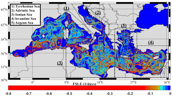
![Snapshots of the FSLE at predefined months over the levantine basin, Ionian and Aegean Sea, similar to the surface Mediterranean circulation, to visualize the distributions of drifter pairs and 30-day trajectories versus the coherent structures (from [Bouzaiene et al., 2020])](/fileadmin/_processed_/e/6/csm_202012_fsle_med-aegean_26506f9f07.png)
A number of things are moving passively with the ocean circulation -- pollutant, phytoplankton, fish eggs and larvae, jellyfish... Estimating how they disperse is thus important for a wide variety of reasons. In the Mediterranean Sea, where the basin is almost enclosed, with populated and very touristic coasts, and a complex geography of sub-basins with their own characteristics, this is all the more useful.
The filaments (FLSE) data are a way of representing the dispersion. Where they are close to zero, two particles located there will stay close to each other a long time. Far from zero the two particles will move away from each other. Low dispersions are localized in the eddies core and the stretching of the fluid parcels are in their outer part. They can thus give an idea of the mean mesoscale features in the different Mediterranean sub-basins.
A study compares those to surface drifter data over the different Mediterranean basins. The drifters are paired (either by design, by having launched by two, or taking benefit of chance proximity), and the tracks of the pairs are used to compute dispersion estimates. The surface flow dispersion regimes seen are different depending on the basins: more isotropic in the Aegean Sea, anisotropic where the zonal motion is dominant.
A better knowledge of surface circulation even in a Sea as studied as the Mediterranean Sea can help in fighting pollution dispersal, or warning of jellyfish presence, etc. Satellite altimetry, combined with other techniques can help, with new techniques to exploit the data appearing along the years.
See also:
- Applications: Mediterranean Sea
- Applications: Mesoscale ocean circulation
- image of the Month, September 2006: Mediterranean currents
- Data: FSLE
Reference:
- Bouzaiene M, Menna M, Poulain P-M, Bussani A and Elhmaidi D (2020) Analysis of the Surface Dispersion in the Mediterranean Sub-Basins. Front. Mar. Sci. 7:486. doi: 10.3389/fmars.2020.00486

