CFOSat
Image of the Month - March 2020
Waves are a key issue for marine services, maritime commerce and coastal urbanization. Understanding and forecasting sea state during storms or hurricanes is a safety issue. Up to end of 2018, two types of satellites were measuring waves. First, the Synthetic Aperture Radars estimate directional waves spectra from the sea surface roughness measurements, but they are limited to long waves. Secondly, the radar altimeters are measuring "only" the significant wave heights at nadir over the whole ocean.
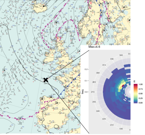
CFOSAT is a French-Chinese satellite launched on October 29, 2018. It carries a wind scatterometer (SCAT) developed by CNSA, but also a brand-new instrument measuring waves (SWIM , a wave scatterometer), developed by CNES. This instrument measures directional wave spectra , i.e. the wave energy as a function of direction and frequency.
SWIM operates in Ku-band (13.575 GHz), frequently used in nadir altimetry. It is a real aperture radar which illuminates the surface sequentially through six beams with six incidence angles: 0°, 2°, 4°, 6°, 8° and 10°. The beams feed horns are mounted on a rotating antenna allowing the scanning of the whole azimuth angles.
The signal backscatter is analyzed for all the emission directions of the rotation, and thus provides wave directional spectra after aggregating the data measured during a complete rotation. The nadir beam operates like a classical altimeter. However, it provides only significant wave height and wind-speed information, sea-surface height cannot be provided (no precise orbit determination, no radiometer). The signal measured by off-nadir beams depends on wave's slope and sea states. It will improve the characterization of ocean processes and the modeling of ocean/atmosphere coupling.
The presence of this wave scatterometer and of a wind scatterometer enables co-located measurements of two essential parameters for marine weather and sea state knowledge for the very first time.
With such information, the marine weather forecasts and the coastal warning (e.g. storm surges) will be improved. CFOSAT has now finished its validation phase, and the data are available for research and pre-operational applications.
See also:
- Data: CFOSat
- Applications: Wind and waves
- Missions: CFOSat
Other web sites on this topic:
- CFOSat on CNES web site
References:
- Hauser D., Tourain C., Hermozo L. Alraddawi D., Aouf L., Chapron B., Dalphinet A., Delaye L., Gressani V., Grouazel A., Guitton G., Husson R., Mironov A., Mouche A., Ollivier A., Oruba L., Piras F., Rodriguez Suquet R., Schippers P., Tison C., 2019: New observations from the SWIM radar on board CFOSAT : instrument validation and ocean wave measurement assessment", submitted to IEEE Trans on Geoscience and Remote Sensing
- Tourain C., F. Piras, A. Olivier, P. Thibaut, F. Boy, JC Poisson, L. Hermozo, D. Hauser, C. Tison, 2019: CFOSAT SWIM adaptiveretracking: description and validation”, submitted to IEEE Trans on Geoscience and Remote Sensing
- Hauser, D. , L. Aouf, B. Chapron, F. Collard, A. Dalphinet, L. Delaye, C. Dufour, F. Gouillon, A. Grouazel, G. Guitton, L. Hermozo, J.-M. Lachiver, A. Mironov, A. Mouche, F. Nouguier, A. Ollivier, R. Rodriguez, P. Schippers, C. Tison, C. Tourain 2019: CFOSAT: New wind and wave observations from the nadir and near-nadir SWIM Ku-Band instrument, Ocean Surface Topography Science Team Meeting, Chicago, Oct. 2019.

