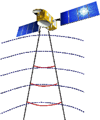
How altimetry works

Altimetry satellites basically determine the distance from the satellite to a target surface by measuring the satellite-to-surface round-trip time of a radar pulse. However, this is not the only measurement made in the process, and a lot of other information can be extracted from altimetry.

The magnitude and shape of the echoes (or waveforms) also contain information about the characteristics of the surface which caused the reflection. The best results are obtained over the ocean, which is spatially homogeneous, and has a surface which conforms with known statistics. Surfaces which are not homogeneous, which contain discontinuities or significant slopes, such as some ice, rivers or land surfaces, make accurate interpretation more difficult.

  • Basic principle

    Radar altimeters permanently transmit signals to Earth, and receive the echo from the surface. The satellite orbit have to be accurately tracked (Doris system) and its position is determined relative to an arbitrary reference surface, an ellipsoid. The sea surface height (SSH), is the range from the sea surface to a reference ellipsoid.

  • Pulses and waveforms

    Altimetry satellites basically determine the distance from the satellite to a target surface by measuring the satellite-to-surface round-trip time of a radar pulse. The magnitude and shape of the echoes (or waveforms) also contain information about the characteristics of the surface which caused the reflection.

  • Frequencies used

    Several different frequencies are used for radar altimeters. Each frequency band has its advantages and disadvantages : sensitivity to atmospheric perturbations for Ku-band, better observation of ice, rain, coastal zones, land masses ... for Ka-band.


  • Delay Doppler / SAR altimetry

    The "SAR-altimetry" or "delay-Doppler altimetry" is a recent technique to process altimetry data.

  • Interferometers

    An altimeter/interferometer includes several altimeters mounted on masts which would acquire measurements simultaneously, thus providing continuous, single- or multi-altimeter wide-area coverage.