Doris applications
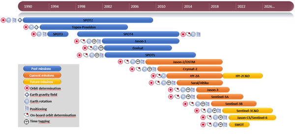
The Doris system was primarily designed for the precise orbit computation required for observing the oceans by altimetry.
The Diode navigator enables to provide the precise satellite position on its orbit in real time.
Doris unique network of ground stations and its highly accurate positioning capability have also proven greatly valuable for geodesy and geophysics applications : measuring the continental drift, fitting the local geodesical network, monitoring the geophysical deformations, determining the rotation and the gravity parameters of the Earth and contributing to the international reference system.
See our applications:
![]() Orbitography
Orbitography
- Precise orbit for Topex/Poseidon, Jason-1, Spot, Envisat, Jason-2, Cryosat-2, HY-2A, Saral, Jason-3, Sentinel-3A, Sentinel-3B
- Mean sea level
![]() Earth gravity field
Earth gravity field
![]() Earth rotation
Earth rotation
![]() Precise positioning
Precise positioning
- Contributing to the International Reference System
- Measuring continental drift
- Mystery in Socorro...
- Measuring a glacier's drift
![]() Navigation
Navigation
![]() Time tagging
Time tagging


