Envisat instruments
RA-2 altimeter
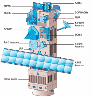
The Radar Altimeter 2 (RA-2) is an instrument for determining the two-way delay of the radar echo from the Earth's surface to a very high precision: less than a nanosecond. It also measures the power and shape of the reflected radar pulses. The RA-2 is derived from the ERS-1 and 2 radar altimeters, providing improved measurement performance and new capabilities. Operating over oceans, its measurements are used to determine the ocean topography, thus supporting research into ocean circulation, bathymetry and marine geoid characteristics. Furthermore, the RA-2 is able to map and monitor sea ice, polar ice sheets and most land surfaces. Measurement of the radar echo's power and shape enables wind speed and significant wave height at sea to be determined, thus supporting weather and sea state forecasting.
Further information
MWR (Microwave Radiometer)
The main objective of the microwave radiometer (MWR) is to measure the integrated atmospheric water vapour column and cloud liquid water content, which are used as correction terms for the radar altimeter signal. Once the water content is known, we can determine the correction to be applied for radar signal path delays for the altimeter. In addition, MWR measurement data are useful for determining surface emissivity and soil moisture over land, for surface energy budget investigations to support atmospheric studies, and for ice characterisation.
Further information
Location systems
The location systems onboard Envisat complement each other to measure the satellite's position on orbit to within two centimetres on the radial component. The LRR is highly accurate, but it requires ground stations that are complex to operate, and its use can be restricted by adverse weather conditions. It is used to calibrate DORIS so that the satellite orbit can be determined as accurately as possible. DORIS measurements determine the orbit in real time to support precise orbit determination.
Doris (Doppler location)
The Doris system uses a ground network of orbitography beacons spread around the globe, which send signals at two frequencies to a receiver on the satellite. The relative motion of the satellite generates a shift in the signal's frequency (called the Doppler shift) that is measured to derive the satellite's velocity. These data are then assimilated in orbit determination models to keep permanent track of the satellite's precise position (to within three centimetres) on its orbit.
Further information
LRR (laser tracking)
The LRR (Laser Retroreflector Array) is an array of mirrors that provides a target for laser tracking measurements from the ground. By analysing the round-trip time of the laser beam, we can locate where the satellite is on its orbit..
Further information
Further information on the instruments (Esa website)

