Envisat Ground Segment
The Envisat ground segment provides the means and resources for managing and controlling the mission, receiving and processing the data produced by the instruments, and disseminating and archiving the products generated. Furthermore, it provides a single interface to the users to allow optimum utilisation of the system's resources in line with their needs.
The ground segment can be divided into two major parts:
* the flight operation segment (FOS), which is responsible for command and control of the satellite;
* the payload data segment (PDS), which is responsible for exploiting the instrument data.
The satellite-to-ground communication links rely on various ground stations (Kiruna, Fucino, Svallbard and Villafranca - the latter as TT&C back-up) and the Esa data relay satellite system, Artemis, which provides direct communication between Envisat and the ground even when the satellite is out of sight of the ground stations. This will enable the use of high-rate sensors whose data cannot be stored on board, optimally managed tape dumps, and enhanced visibility for command and control. Additional national and Esa ground stations will be involved.
Payload Data Segment (PDS)
Role of the PDS
Architectural elements
PDS product distribution
Processing and archiving centres (PAC)
Processor algorithms
The PDS comprises all the ground segment elements related to payload data acquisition, processing and archiving. It also includes the user interface facilities which offer Envisat services to the user community.
For more detailed information see the PDS Detailed Description.
Role of the PDS
The PDS provides all services related to the exploitation of data produced by the instruments carried on the Envisat satellite:
- all payload data acquisition for the global mission;
- all regional data acquisition performed by Esa stations;
- processing and delivery of Esa near-real-time products;
- archiving, processing and delivery of Esa offline products with the support of processing and archiving centres (PACs);
- interfaces with national and foreign stations acquiring regional data;
- interfaces with the user community from order handling to product delivery.
Architectural elements
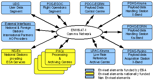
Overview of the PDs architectural elements
The PDS comprises:
Esa provided centres and stations:
- the payload data control centre (PDCC) at Esrin;
- the payload data handling station (PDHS) at Esrin and Kiruna;
- the payload data acquisition station (PDAS) at Fucino;
- the low-rate reference archive centre (LRAC) at Kiruna.
Centres and stations procured nationally:
- the processing and archiving centre (PAC's) located at Esa member states;
- the national stations providing Esa services (NSES) and located in programme participating states.
The PDS also interfaces with national and foreign stations duly authorised to receive Envisat regional data.
All PDS centres and stations is coordinated by the payload data control centre (PDCC) which is in charge of instrument and ground segment planning and of the overall PDS monitoring and control. The PDCC interfaces with the flight operation control centre (FOCC) for all mission planning activities.
PDS product distribution
Two categories of product distribution services are provided by the PDS:
Near real time services
- " typically three hours from acquisition for data used in forecasting or tactical operations (global and regional products produced and distributed systematically);
- " typically one to three days from acquisition for applications requiring high-resolution images (agriculture, forestry, soil moisture, etc.) with production and delivery to users on request.
Off-line service
Continuity of services from near real time to off-line:
- delivery a few days to weeks from data acquisition;
- product commonalities (same format, same processing algorithms whenever possible);
- off-line products benefit from a posteriori knowledge of calibration, auxiliary data, and precise orbit.
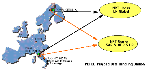
Payload data handling stations for off-line users
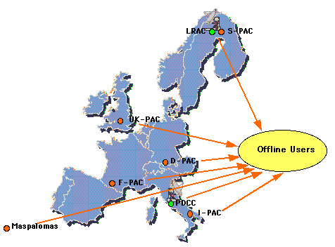
Processing and archiving Centres (PAC)
The processing and archiving centres, located in Esa member states, archive and process off-line high rate data and generate off-line geophysical products for the regional high-rate and full-resolution instruments and for the global low-rate instruments. Altimetry processing and archiving centre is located at F-PAC
Processor Algorithms
The algorithms and processors used in the PDS are developed and validated independently of the PDS industrial activities.
Further information on Envisat ground segment (Esa website)

