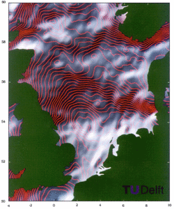
Mean sea surface over the North Sea
Edwin Wisse, Remko Scharroo, Marc Naeije and Karel Wakker (Delft University of Technology, The Netherlands)
A mean sea surface over the North Sea was created by combining all available data from three satellites (Geosat, ERS-1, and Topex/Poseidon): the full Geosat dataset, the first 17 months of ERS-1 (FDPs), and the first ten Topex/Poseidon 10-day cycles (Aviso IGDR-Ms). The radial orbit error was reduced by minimizing crossover residuals in a least squares sense. The data were interpolated to a rectangular grid using objective mapping. The resulting mean sea surface was high-pass filtered.
The surface is illuminated from the northwest to show small-scale details; contours were plotted every 25 centimeters.
Some bottom topography features are visible in the northwestern part of the area.
In this area the mean sea surface shows mainly geological features. Between the Danish and the northern Dutch coast a number of "Graben" can be seen; these are old faults which were later filled with sediment.
The Ringkobing/Fyn High, west of Denmark, is clearly visible.


