TOPEX/POSEIDON and the wind
J.M. Lefèvre and J. Barckicke (Météo France, France) - Y. Ménard (CNES, France)
Météo France is involved in the TOPEX/POSEIDON program because it is interested in operational use of satellite data. Near-global coverage by the onboard altimeters is an advantage for assimilating the data into operational numerical models.
The data is also useful as a short-term weather forecasting aid. Our main investigations aim at improving estimates of two geophysical parameters: surface wind speed modulus (U) and significant wave height (H).
The wind modulus is also useful for determining sea level: we use it in parametrizations of electromagnetic bias, needed to correct altimeter ranges.
The radar altimeters receive a complex signal due to specular reflection of the pulse on a surface of some 4 km in diameter.
The effective backscattering cross-section (sigma) can therefore be seen as depending on the shape of the sea-surface, or statistical moments of the slope. As a first approximation, the most significant parameter is the mean quadratic slope. Capillary slopes are mainly due to the wind, while those of the large-scale components are due to waves. It therefore makes sense to express the wind by a relation U=f(sigma,H). We use a second-order polynomial in H and sigma:
U = a00 + a10H + a01sigma + a11Hsigma + a20 H2 + a02sigma2
The number of spatial data values co-located with surface measurements is generally limited to a few hundred over periods of a few years. However, using wind/wave data from operational numerical models to calibrate the function gave us a large data set of around 17,000 values. We filtered out doubtful model and altimetry data by removing values with too great a discrepancy between model and altimeter wave heights.
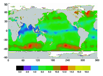
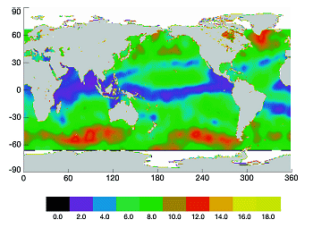
By introducing H in the transfer function we reduced the standard deviation of the wind error from 1.74 m/s to 1.67 m/s, using functions depending only on sigma. The data set was large enough for this reduction in variance to be significant with better than 99.9% confidence. The function was calibrated for the ALT altimeter, then validated with SSALT data. Figure 1, a composite image based on the tracks of cycle 20, shows the wind spatial distribution from the new algorithm (LBM) and from POSEIDON data. The same distribution with the Modified Chelton Wentz (MCW) algorithm shows striking differences of up to 2 m/s, particularly in tropical areas.
Reference :
- Lefevre, J.M., Barckicke, J. and Y. Ménard, 1994, A SWH
 -dependent function for TOPEX/POSEIDON wind speed retrieval, J. Geophys. Res. (in press).

