Altimetry in videos: Mean Sea Level
Almost three quarters of the Earth’s surface are covered by oceans: oceans are a key-element of our global climate system. It is a reality, the oceans respond to climate change: as a result of human activity and greenhouse gases, the climate is warming, the ocean expands and its level rises. Oceans are under close surveillance at all times: altimetry satellites accurately measure the sea level with a homogeneous and continuous global coverage since the launch of Topex-Poseidon in 1992. The Jason-3 mission will soon complement this satellite constellation currently in flight by providing continuity of measurements that is essential for observing climate change.
Altimetry satellites tell us precisely how climate change is impacting rising sea level.
Benoit Meyssignac, Cnes/Legos: "Satellites have been precisely measuring the rise in sea level since 1993, with Topex and then Jason-1 and Jason-2, soon to be joined by Jason-3. These satellites are capable of estimating sea level with an accuracy of around 0.6 mm/year, and they’re telling us it’s risen at a rate of 2 mm/year since 1993."
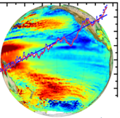
The global picture that satellites offer is a key advantage over point tide-gauge readings.
Benoit Meyssignac, Cnes/Legos: "With satellites, we obtain a picture of regional variations in sea level. In other words, we see that sea level isn’t rising uniformly but faster in some parts of the globe than others. For example, in the Western Pacific it’s risen by up to 10 or 11 mm/year over the last 20 years, while in other regions like the West Coast of the United States it’s risen very little and in fact fallen at a rate of 0.5 mm/year over the same period."
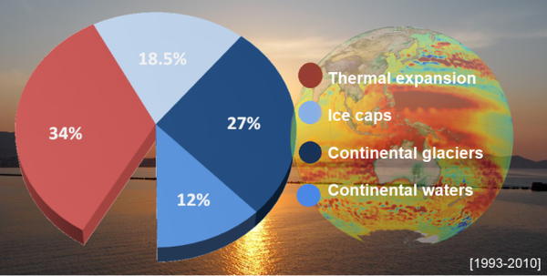
Four factors are at work:
- expansion of warming water
- melting of the polar ice caps
- melting of continental glaciers
- and the influx of surface waters
Benoit Meyssignac, Cnes/Legos: "Sea level rise hasn’t accelerated since we started observing it with satellites in 1993. On the other hand, if we look for a longer period over the 20th century, tide-gauge measurements indicate that before 1990 sea level rose more slowly, at a rate of about 1.5 mm to 1.7 mm/year. It therefore started to rise faster towards the end of the 1980s and in the 1990s."
Predictions for the 21st century are more ominous.
Benoit Meyssignac, Cnes/Legos: "One of the reasons sea level is now rising, the main reason in fact, is greenhouse gas emissions. In the future, we expect these emissions to increase and so sea level will rise faster. By the end of the 21st century, we expect sea level to be between 25 and 95 cm higher than it is today.
That’s a broad range of values factoring in all of the uncertainties regarding climate predictions for the end of the 21st century. There are uncertainties about future greenhouse gas emission scenarios, uncertainties in how sea level is modelled in climate models, and uncertainties due to the chaotic nature of Earth’s climate system."
Continuous monitoring by satellites is therefore vital to gauge future sea level rise, define regions at risk and anticipate disasters.
Further information:
- Missions: Jason-3
- Ocean Indicators: the Mean Sea Level
- Products and images
- References
- Applications: Mean sea level rise and greenhouse effect
- Alltimetry in videos : all videos
- Multimedia gallery: mean sea level topic, climate topic

