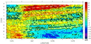
El Niño on time for Christmas
Image of the month - January 2007
This year El Niño, true to its name (El Niño, i.e., the (Christ) child in Spanish), showed up for Christmas. However, if El Niño is more evident towards the end of December, it has already been brewing for some months. Since the beginning of April 2006, warm waters arrivals (or sea surface height elevations) coming from the Western Pacific have been following each other near the South American coasts, the stronger being end of December 2006 - beginning of January 2007. These warm water masses move impact the atmosphere, and thus the weather, all over the world, but especially around the Pacific.
Even if the current El Niño is rather weak, it can have some effects. It is possible, in particular, that it has a role in the current drought in Australia.
Altimetry is among the monitoring techniques for such phenomena, from which forecasting and a better knowledge can be brought.
See also:
- Ocean's hot news: El Niño bulletin
- Applications: El Niño
- Diagram and map plotting: Live Access Server
Websites on this subject:
- ENSO Wrap-Up (Bureau of Meteorology, Australia)
- Ocean Interpreted bulletin - El Niño (Mercator Océan)


