Counting icebergs
Image of the month - November 2008
Icebergs are a known feature of high-latitude seas. "Small" icebergs (smaller than 1 km2) are difficult to detect on a global scale using sensors onboard satellites, due to their size, to cloud cover, etc.
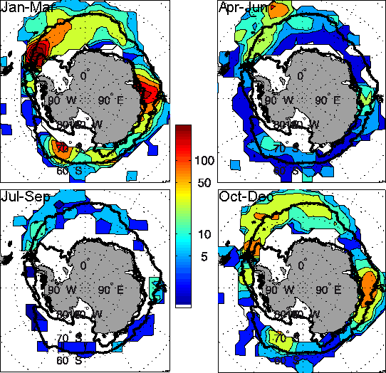
Satellite altimetry is able to detect objects rising straight over the sea surface (see Image of the Month, April 2006: Beacons in the waveforms). If we observe the return echoes of the altimeter (or waveforms), we can note an "earlier" return of the signal when there's something rising over the sea on which the radar beam can be reflected, provided it is not too high nor too big. For objects higher than 15 m, the signal would arrive before the radar is "ready" to record it, and bigger than 1 km2 , the return echo shape would then be closer to one obtained over a different surface than ocean (ice, in the case of icebergs). Applied on one year of Jason-1 waveforms, in the Southern sea around Antarctica, this enabled to make a census of icebergs. More than 8000 icebergs were detected along that year, with their seasonal and geographical patterns in agreement with other studies.
If such a method can't serve as an alert system for navigation, it can be very interesting regarding ice caps response to climate change, by giving statistics on the number of icebergs shed.
See also:
- Applications: Ice sheets and sea ice
- Data: Waveforms
References:
- Tournadre, J., K. Whitmer, and F. Girard-Ardhuin (2008), Iceberg detection in open water by altimeter waveform analysis, J. Geophys. Res., 113, C08040, doi:10.1029/2007JC004587

