Gliding in the sea
Image of the Month - August 2009
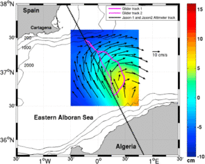
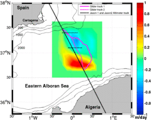
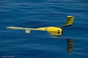
Gliders are relatively new ocean-measuring devices. Autonomous underwater vehicles, they glide in the waters with a payload of instruments onboard, measuring all the while temperature, salinity, currents, chlorophyll, pressure... Such instruments are typically presented as complementary to satellites - they are measuring underwater, where the satellites can't, but locally, when the satellites give global coverage (satellite altimetry, however, is a bit special among the space measurements, since it depends on what is in the whole water column, from top to bottom).
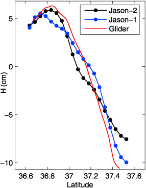
Thus, mixing altimetry and glider data can provide information not available with either one separately, for example about the way waters are moving vertically.
See also:
- Image of the Month, June 2009: A corridor of eddies
- Data: Ssalto/Duacs near-real and delayed time multimission altimeter products
- Applications: multi-sensor applications
References
- Ruiz, S., A. Pascual, B. Garau, I. Pujol, and J. Tintoré, 2009: Vertical motion in the upper ocean from glider and altimetry data, Geophys. Res. Lett., 36, L14607, doi:10.1029/2009GL038569.
- Ruiz, S. A. Pascual, B. Garau, I. Pujol, J. Tintoré, 2009: Vertical motion in the upper ocean from glider and altimetry data, poster, OSTST meeting, Seattle, June 2009
- Pascual, A. , S. Ruiz, B. Garau, Y. Faugère, M-I. Pujol, M. Martínez, G. Larnicol, J. Tintoré, 2008: Performing Glider missions along altimeter tracks: what can we learn ?, poster, OSTST meeting, Nice, November 2008

