A corridor of eddies
Image of the Month - June 2009

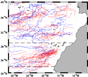
Eddies are seemingly sowed more or less haphazardly in the ocean (Image of the Month, September 2007). However, regular features exist, especially when there are dominant winds and/or currents, and islands or other topographic features. The "Canary Eddy Corridor" is a recurrent feature that can be detected in the more than 16 years of merged altimeter data. The phenomenon is an East-West corridor of eddies, born of the perturbation of the Canary Current flow and of the Trade Winds at Canary Islands. It extends from the Canaries to at least 32°W, close to the Mid Atlantic Central Ridge. Anticyclonic long-lived eddies (a few years life span) have been observed as far west as 50°W, well beyond this Ridge.
Altimeter observations and drifter trajectories indicate that the eddies in this corridor first propagate South (following the Canary Current flow); then, at about (18°W, 25°N), they move westward (with a slight southward direction for anticyclonic eddies), on average at about one degree per month.
The availability of a long series of altimetry measurements enable to detect and visualise permanent features of the ocean dynamics.


See also:
- Image of the Month, Sep. 2007: Altimetry on eddies' tracks
- Image of the Month, Jan. 2006: Merging of altimetry data: proofs from other measurements
- Applications: Combining sensors
- Data: Ssalto/Duacs near-real and delayed time multimission altimeter products
References
- Sangrà, P., A. Pascual, Á. Rodríguez-Santana, F. Machín, E. Mason, J.C. McWilliams, J.L. Pelegrí, C. Dong, A. Rubio, J. Arístegui, Á. Marrero-Díaz, A. Hernández-Guerra, A. Martínez-Marrero, M. Auladell, The Canary Eddy Corridor: a major pathway for long-lived eddies in the subtropical North Atlantic, submitted to Deep Sea Research


