35 years of altimetry!
Image of the Month - January 2014
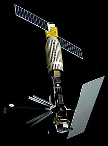
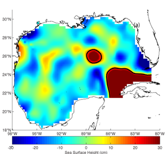
Seasat, left (credits Nasa). Right, Loop current eddy as observed by Seasat approximately 2 weeks after eddy separation as a Sea Surface Height anomaly color image with a 17-cm contour overlaid (used to track loop current eddies) from along track data from July 16 through August 9, 1978. The analysis date of the mapped data is July 28, 1978. (credits CCAR)
We tend to speak of our "20-year altimetry record". However, the first altimetry missions are much older than 1991-1992 (resp. ERS-1 (Esa) and Topex/Poseidon (Nasa/Cnes)). The very first tries at space altimetry were made onboard Skylab (Nasa, 1973-74) and Geos-3 (Nasa, 1975-78), but the first real convincing results were made with SeaSat (Nasa, 1978). Sadly, this satellites worked only three months, but it was the starting point of several space oceanography techniques, which gave us a global view of ocean circulation, waves and winds, etc. Concerning altimetry, Seasat was the start of Topex (afterwards merged with the French Poseidon project), and Geosat (1985-89, US Navy/Noaa).
Now, the measurements continue on, with among other the latest missions (Saral (Cnes/Isro), HY-2 (CNSA)), the very next ones (Sentinel-3 (Esa/EU), Jason-3 (Cnes/Nasa/Eumetsat/Noaa), Jason-CS (Esa/Eumetsat/Noaa/UE/Cnes/Nasa)), and the more long-term, and technically innovative ones (Swot, Nasa/Cnes/CSA).
See also:
- Applications: Mesoscale circulation
- Image of the Month, April 2003: A looping current
- Missions: past missions
Websites on this subject:
- CCAR Ocean Data Viewer Pages
- How the eddies are created (Quarterdeck magazine, Texas A&M University)
- Loop Current (Micom model)
References
- R. R. Leben et al., A 34-Year Record of Loop Current Eddy Separation Events, OSTST, Venice, 2012

