El Niño played hide and seek in 2014
Image of the Month - January 2015
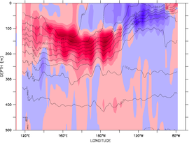
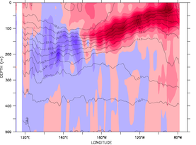
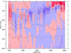
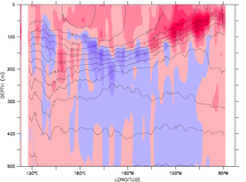
Temperature anomalies (color scale) and absolute (contours) sections averaged over 2°S-2°N in the Tropical Pacific, for February, May, July and December 2014. The situation showed a temperature increase near the American coasts in May, but this positive anomaly faded by July. In December, a very weak El Niño is visible at Christmas. (temperatures from Guinehut et al. / Mulet et al. Credits CLS/MyOcean)

In February - March 2014 and up to May, an El Niño was announced, possibly a strong one. All conditions seems similar to 1997, and thus forecasts were close to that episode. However, sea surface temperature was high all over Tropical Pacific, with few or no temperature gradient. However atmosphere answers to surface temperature gradients by pressure gradients, i.e.: winds. So, no winds, no "southern oscillation", and ENSO disappeared. This illustrates that all observations are necessary to be taken into account in climate forecasts such as ENSO's, on the Ocean surface, the atmosphere, but also in depth.
Altimetry, combined with others space techniques, but also with in situ arrays like TAO and Argo enables to reconstruct the whole ocean in 3 dimensions, as done for the Global Ocean Observation-based Product "Armor3D" (Guinehut et al. / Mulet et al).
See also:
- Data/Ocean indicators: El Niño bulletin
- Applications: El Niño
- Diagram and map plotting: Live Access Server
Websites on this subject:
- Access to the 3D temperature data ("Armor3D" dataset, MyOcean)
- Climate.gov (Noaa) ENSO blog
References
(for the data used in the sections)
- Guinehut S., A.-L. Dhomps, G. Larnicol et P.-Y. Le Traon (2012). High resolution 3-D temperature and salinity fields derived from in situ and satellite observations. Ocean Sci., 8(5):845–857.
- Mulet S., M.-H. Rio, A. Mignot, S. Guinehut & R. Morrow (2012). A new estimate of the global 3D geostrophic ocean circulation based on satellite data and in-situ measurements. Deep Sea Research Part II : Topical Studies in Oceanography, 77–80(0):70–81.

