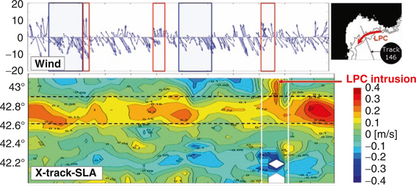
Current intruding on the continental shelf
Image of the Month - June 2015

In the Mediterranean Sea, you're never far from a coast. This, and the very complex shape of those coasts make the currents there quite complicated (and its scheme is still in debate). Coastal dedicated data thus can help a better knowledge of the Mediterranean. In the Gulf of Lion, South of France, a current, the Liguro-provencal current, usually follows the continental shelf from Marseille to Cataluña. However, when winds blow northwards, the current can intrude on the shelf.
Classical altimetry data do not fully track such intrusions, because the data are usually removed from "open-ocean" dedicated datasets since they are less reliable too close to the coast. However, research is ongoing, and new datasets provided in order to fill this gap as best as possible.
Saral enables to get closer to the coasts, due to the use of the Ka band. And, in the future, SWOT should get a much finer picture of such areas.
See also:
- Data: X-Track SLA regional data (Mediterranean Sea)
- Applications: Mediterranean Sea
- Applications: Large-scale ocean circulation
- image of the Month, September 2006: Mediterranean currents
References:
- Bouffard J., L. Roblou, F. Birol, A. Pascual, L. Fenoglio-Marc, M. Cancet, R. Morrow, and Y. Ménard, 2011: Introduction and Assessment of Improved Coastal Altimetry Strategies: Case Study over the Northwestern Mediterranean Sea, S. Vignudelli et al. (eds.), Coastal Altimetry, DOI: 10.1007/978-3-642-12796-0_12, © Springer-Verlag Berlin Heidelberg 2011
- Birol F. M. Cancet and C. Estournel, 2010: Aspects of the seasonal variability of the Northern Current (NW Mediterranean Sea) observed by altimetry, Journal of Marine Systems, 81, pp 297-311, doi:10.1016/j.jmarsys.2010.01.005.
- Bouffard, J. , 2007: Amélioration de l’altimétrie côtière appliquée à l’étude de la circulation du Bassin Nord Occidental de la en Mer Méditerranée, PhD Thesis, Université P. Sabatier, Toulouse.


