A future insight to English Channel
Image of the Month - October 2015
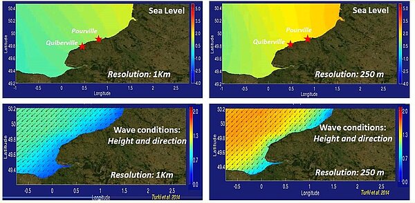
One of the first results from an altimeter was on the tides in the English Channel seen by Seasat. Since then, altimeters have improved their accuracy, but the English Channel remains a tricky area. More broadly, coastal altimetry is still in development. On the other side, in the area, only six tide gauges are installed on the French side of the Channel, a quite sparse sampling. With Swot, such areas will be observed with a 120-km swath in high resolution thus leading to a huge improvement in such measurements, needed to modelize coastal sea levels and circulations.
Tests of different scenarii were made (stormy/moderate events, neap/spring tide cycle and low/high tides, including storm surges) using several grid resolution. Results are that a 250-m SWOT grid will enable to estimate the annual and the seasonal variability of the nontidal sea level, capturing 80% of the variability. In particular, it is able to reproduce the most of extreme storm surges in the English Channel.
The Swot mission, to be launched in 2020 will revolutionize altimetry with a large-swath. Applications will include hydrology, but also coastal and submesoscale oceanography.
See also:
References:
- Turki, I.; Laignel, B.; Chevalier, L.; Costa, S.; Massei, N., "On the Investigation of the Sea-Level Variability in Coastal Zones Using SWOT Satellite Mission: Example of the Eastern English Channel (Western France)," in Selected Topics in Applied Earth Observations and Remote Sensing, IEEE Journal of , vol.8, no.4, pp.1564-1569, April 2015
doi: 10.1109/JSTARS.2015.2419693 - Le Provost, C. Brossier 1981: SEASAT Altimeter Measurements Over the English Channel: An Error Analysis, Oceanography from Space, Marine Science, J.F.R. Gower ed.


