Wind and Waves

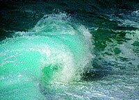
Spaceborne altimeters measure sea surface height first and foremost, but we can also obtain other physical parameters using satellite altimetry techniques. One such example is wave height, which is of prime importance to marine weather forecasters and ships at sea. Wave height can be derived by looking at how the sea surface reflects the radar signal.

  • Seasonal variations

    Wave height and wind speed are highly dependent on the season, especially around the Antarctic, where winds and currents are not blocked by any continent.


  • Atlantic storm

    On December 9, 2007 a strong storm hit North-East Atlantic coasts, with wave heights over 14 m. Altimeters helped monitoring the model quality near French coasts.

  • Southern Swell in the Indian Ocean

    Example of a southern swell occured in the Reunion Island (Indian Ocean). This phenomenon is due to an heavy storm around 40°S (the famous 'roaring forties'), South of Africa. The storm engendered swell, which propagated in the Indian Ocean at about 1000 km/day, in a region where low winds do not disrupt the swell.


  • Rogue waves

    They are mostly individual waves of exceptional height and/or abnormal shape which cannot be detected with altimetry, as it averages measurements over several square kilometers. But studies try to link the occurrence of such waves to some sea state properties.

  • Sail races

    Altimetry and Argos system can help to track and secure sailboats anywhere in the world. Examples of sail races and analyses to pick the right route.