Cyclones, hurricanes and typhoons
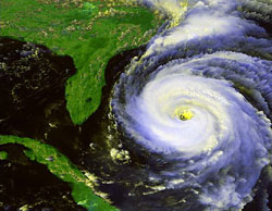
Tropical cyclones (known as hurricanes in the tropical Atlantic, western Pacific and northern Indian oceans; as typhoons in the eastern Pacific Ocean; and as cyclones in the southern Pacific and Indian oceans) are characterised by very high waves and strong winds, that can be measured by altimeters (provided that the satellite flies close enough to the area affected by the cyclone) and assimilated in real-time in some forecasting models. However, altimetry can also help identify the warm features that can cause these storms to intensify.
Cyclone intensification
The role of the ocean in hurricane formation is known. The formation of hurricanes has been linked to the sea surface temperature and values of this parameter higher than 26°C. But this necessary condition is not sufficient. Sea surface temperature provides a measure of the surface ocean conditions, but tells us nothing about the subsurface ocean thermal structure in the first tens of meters. Altimeter data are used to investigate the relationship between hurricane intensification and upper ocean thermal structure under the storm track. These thermal structures, like some anticyclonic eddies, are described by sea height anomalies (SLA) measured by altimetry. A parameter nammed Tropical Cyclonic Heat Potential (TCHP) integrates these anomalies with the sea surface temperature and the mixed layer depth. The Tropical Cyclonic Heat Potential is even higher than the surface water is warmer and the 26 °C isotherm is deep.
Assimilation in wave models
Altimetry can also play a part in cyclonic event warnings using significant wave height (SWH) measurements in near-real time (three hours). Once they have been assimilated in sea state forecast models, wave heights from altimetric satellites significantly improve their predictions (See Applications Wind and waves).
Further information :
- Altimetry applications in videos: Monitoring Hurricanes
- Lively Data :
- October 2, 2007 : Trajectory of the cyclone Dean.
- 14 octobre 2005 : Wind and waves.
- Newsletter #9, 2003 : Using satellite altimetry to identify regions of hurricane intensification, Goni and al. pdf (1.3 Mo).
- Poster : Monitoring Hurricane Isabel (pdf)
- Radar Altimetry Tutorial, Cyclones, hurricanes and typhoons.
- National Hurricane Center (Noaa).
- Nasa "Recipe for a Hurricane"
- Météo France, Tropical cyclones

