
Assimilation in wave models
End of Summer and beginning of Fall are hurricane season in the Atlantic, when water reaches or exceeds 26°C over the first 60 meters (which are the conditions for a storm to become a hurricane). In 2004, a very high number of hurricanes struck the area with appalling human and economic consequences. On September 15, a buoy measured a significant wave height of 16 m (some waves went over 25 m) in the Gulf of Mexico under Ivan path. That is the highest wave height measured in the area during a hurricane (which doesn't mean even higher waves did not occur during this hurricane where there was no buoy to measure them). Sea state forecast during such events are a test for the models -- and an important information for seafarers.
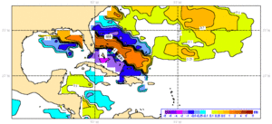
Altimetry can play a part in such event warnings, with its information about sea surface height (see Hurricane intensification above hot waters), but also with significant wave height measurements. Once assimilated in sea state forecast models, wave heights from altimetric satellites improve significantly their predictions. With data from two satellites, Jason-1 (Cnes/Nasa) and Envisat (Esa) assimilated, they are even more accurate.
Further information :
- Image of the month, April 2005 : Series of hurricanes.

