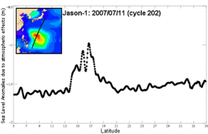
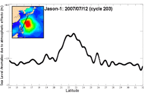
Man-Yi typhoon struck the Japanese Okinawa island mid-July 2007, with winds blowing at speeds between 230 and 295 km/h. It caused several casualties, as well as important material damage. Typhoons are quite frequent in the region, but they usually appear later in the year; Man-Yi is probably the strongest typhoon ever observed in July. Such meteorological monsters (called cyclones, hurricanes or typhoons depending on the region) feed upon the ocean heat to release a huge quantity of energy. They causes raging winds (winds faster than 33 m/s --118,8 km/h --are a criterion to classify a tropical storm as cyclone), very high waves, torrential rain, and all the damages that follow.
Sea level anomalies due to the effects of atmosphere on the sea surface, as measured by Jason-1 over the Man-Yi typhoon (top left, the plotted Jason-1 ground track overlaid on a significant wave height map at the same time). The typhoon causes a sea surface height increase of about 50 cm (ocean variability has been removed). Specific processing were applied in such extreme cases as cyclones.
(Credits CLS).
Further information :
- Image of the month, August 2007 : Altimetric views of a typhoon (animations).


