A subglacial lake in network

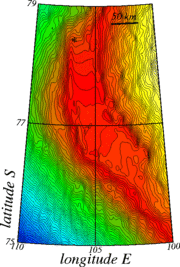
Lake Vostok is a liquid, freshwater lake lying under a three-kilometer blanket of ice in the middle of the Antarctic continent. Here, rather than deforming as it flows (with the steepest slope), the ice sheet slides over the water, forming a plateau 40 kilometers across and 100 kilometers long. From the high resolution topography achieved by ERS-1 (geodetic phase), we are able to draw a topographic map underlining this huge plateau (maps on right) or to deduce the topography curvature (map below) that highlights the irregularities of the ice grounds and ice flow anomalies.
On the topography curvature map, between Lake Vostolk and Dome C (where the French-Italian Concordia base is), we can see linear, elongated, features that seem to link the numerous lakes discovered in this area. Other clues, like the fact that these features follow the slope of the bedrock, lead to think that they are sub-glacial hydrological networks linking the lakes between each other.
The fact that such hydrological networks exist is important to understand Antarctica and the way ice are flowing on this continent. Moreover, Lake Vostok is of great interest to researchers seeking to retrace the history of Earth's climate, as its waters could hold the key to what climate was like several million years ago. Ice cores have already been recovered from the area (marked by the star on the map on right), but operations have now stopped until we can develop drilling techniques that will enable us to breach the lake's surface without contaminating it. Altimetry contributes to this knowledge of the biggest iced terrestrial water stock.
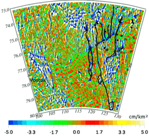
Ice surface topography curvature map in the area between Lake Vostok and Dome C in Antarctica. Black lines show the hydrological network detected under the ice that links the small sub-glacial lakes in the area (marked with stars). (Credits Legos).

