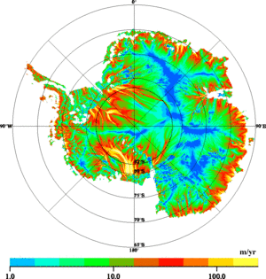
Speed of ice flow in Antarctica
Observing the ocean surface is not the only application of satellite altimetry. Satellites also serve to measure the surface topography of sea ice and glaciers on land-although ice and sea water do not, of course, reflect the radar altimeter beam in the same way. ERS-1 and ERS-2 are two Earth observation satellites providing coverage of the Earth's polar ice caps up to 82 degrees north and south, thus allowing us to observe large areas of the Antarctic.
By measuring the relief of glaciers, we can determine how fast they are moving. We now know from satellite observations that fast-flowing "rivers of ice"-moving at speeds up to one kilometer per year, comparable to that of glaciers in the Alps or the Andes-are found a long way inland. Such findings are completely changing our understanding of the polar ice caps.
Today, continuous monitoring by altimetry satellites of glaciers in the Antarctic and in Greenland is also yielding important data for research into global warming and the rise in sea level.

