Cryosat Instruments
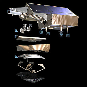
Cryosat-2's primary payload is the SAR/Interferometric Radar Altimeter (Siral), which has extended capabilities to meet the measurement requirements for ice-sheet elevation and sea-ice freeboard. Cryosat-2 also carries three star trackers for measuring the orientation of the baseline and calibrate the baseline orientation. In addition, a radio receiver called Doppler Orbit and Radio Positioning Integration by Satellite (Doris) and a small laser retroreflector ensure that Cryosat-2's position is accurately tracked.
Siral altimeter
Siral is an altimeter/interferometer operating in Ku-band (13.575 GHz) in three modes :
- Low-resolution, nadir-pointing altimeter mode,
- SAR mode,
- SAR interferometer (SarIn) mode.
The altimeter measures the distance between the satellite and the surface of the Earth.
Unlike conventional radar altimeters, where the interval between pulses is about 500 microseconds, the Cryosat altimeter sends a burst of pulses with an interval of only 50 microseconds between them. The returning echoes are thus correlated, and by treating the whole burst of pulses in one operation, the data processor can separate the echo into strips arranged across the track by exploiting the slight frequency shifts (caused by the Doppler effect) in the forward- and aft-looking parts of the beam.
In order to measure the arrival angle, a second receive antenna is activated so that the radar echo is received by two antennas simultaneously. When the echo comes from a point not directly beneath the satellite there is a difference in the path-length of the radar wave, which is measured. Simple geometry provides the angle between the baseline joining the antennas and the echo direction.
Further information
Location systems
The location systems onboard Cryosat-2 are complement each other to measure the satellite's position on orbit to within two centimetres on the radial component. The LRR is highly accurate but it requires ground stations that are complex to operate, and its use can be restricted by adverse weather conditions. It is used to calibrate DORIS measurements in order to determine the orbit in real time and to support precise orbit determination.
Doris (Doppler location)
The Doris system uses a ground network of orbitography beacons spread around the globe, which send signals at two frequencies to a receiver on the satellite. The relative motion of the satellite generates a shift in the signal's frequency (called the Doppler shift) that is measured to derive the satellite's velocity. These data are then assimilated in orbit determination models to keep permanent track of the satellite's precise position (to within three centimetres) on its orbit.
Further information
LRR (laser tracking)
The LRR is an array of mirrors that provide a target for laser tracking measurements from the ground. By analysing the round-trip time of the laser beam, we can locate where the satellite is on its orbit.
Further information
Further information on Cryosat-2 satellite (Esa website)

