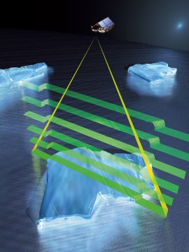
Cryosat mission's objectives

Cryosat's mission is dedicated to monitoring very precise changes in the elevation and thickness of polar ice sheets and floating sea ice over a three-year period. The observations made by Cryosat will determine whether or not our ice masses are thinning due to global warming.
Cryosphere's role
The cryosphere plays an important role in moderating the global climate. Due to their high albedo, ice masses directly affect the global energy budget by reflecting about 80% of incident sunlight back out to Space. Thus, once formed, ice tends to be maintained. However, if ice cover were to decrease, less solar radiation would be reflected away from the surface of the Earth - causing the ice to absorb more heat and consequently melt faster still (commonly named a positive feedback).
Ice sheets and glaciers are a control on sea level. They are the largest uncertainty factor in determining the source of the present rise in sea level.
Cryosat measurements
Fundamentally, there are two types of polar ice: the ice that floats in the oceans and the ice that lies on land. Not only do these two forms of ice have different consequences for our planet and its climate, they also pose different challenges when trying to measure them from Space.
Floating sea ice
Sea ice is relatively thin - up to a few metres thick, but it influences regional temperature and the circulation of ocean currents, and consequently the Earth's climate. Cryosat will acquire precise measurements of the thickness of floating sea ice so that annual variations can be detected.
Cryosat will determine the thickness of floating sea ice by measuring the freeboard of ice floes; that is the height by which the ice extends above the water's surface. Cryosat will achieve improved spatial resolution of 250 m in the along-track direction using the Synthetic Aperture technique.
Ice-shelf break up
In contrast, the ice sheets that blanket Antarctica and Greenland are several kilometres thick. The growth and shrinkage of these ice masses have a direct influence on sea level. The approach used for measuring these vast thicknesses is to determine the height of the surface accurately enough to detect small changes.
Further information: Cryosat science overview (Esa website)


