Closer to the coasts
Image of the month - July 2006
What most people are interest in about the sea is mostly at the beach level (especially in Summer), or at the furthest, just abroad the harbors and river mouthes, than at the open sea level. For a long time, those coastal areas have been put aside by altimetry. Now, with knowledge increase and 15 years of conitunous experience in radar altimetry, altimetry data enhancement near the coasts is under study in several scientific teams around the world.
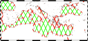
For Jason-1 or Topex/Poseidon, the areas where radiometer measurements are typical edited by the standard processings (in red) and the ones where there are kept (in green). The Egean Sea, in particular, is thus completely put aside. (Credits CLS)
This shortage of altimetry data (or their lower quality) near the coasts is due to several things:
- to the technique in itself, since the radar echoes reflected over water or over water and land mixed are not identical, and only the former are processed, basically, by the ground segments. Other altimetry satellite measurements have also the same problem, like the radiometer (at a distance of about 50 km from the coast)
- to the fact that the basic distributed data (GDR) are mainly average over one second, thus covering about 7 km (data averaged over 1/20 s exist, however).
- To the computation of some corrections. Tides, in particular, are much more complex near the shores than in the open sea, and request a high precision on the coastal geography to be accurately computed. Moreover, rapid variations ("high frequency") must be taken into account in those areas (for the tides as well as for the atmospheric pressure). Wet tropospheric corrections, computed from radiometer measurements are also less precise, or even missing, near the coasts.
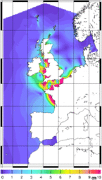
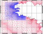
Left, M4 tidal component amplitude - a non-linear component, thus difficult to modelized -. This component is high near the French and British coasts, in particular. Right, the kind of grid used to compute tides at regional or local scale.
(Credits Legos)
See also:
- Applications: Tides
- Data: Regional products
Websites on this subject:
- Symposium "15 Years of Progress in Radar Altimetry", Coastal Oceanography session and posters
- Coastal Oceanography (Observatoire Midi-Pyrénées)

