Drifting buoy
Image of the Month - May 2013
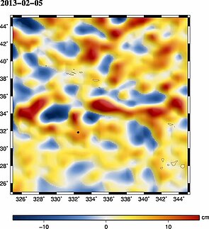
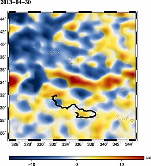
Sea Level Anomalies at the moment of Acciona capsize (Feb. 3, 2013) and nearly 3 months later (April 30) with the path of the drifting beacon overlaid. See the animation (mpeg4, 830 KB or avi, 1.2MB) (Locations Argos, buoy followed in the Argonautica educational project frame)
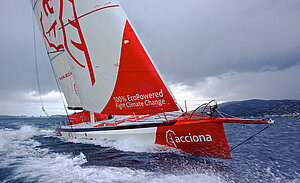
The Acciona sailing boat, which took part in last Vendée Globe alone-the-world sailing race, is a ship entirely powered by renewable energies, without any fossil fuel onboard. There were only 1,400 milles left (about 5 days) to the finish line in the Sable d'Olonne harbour when she capsized on February 3 near the Azores Islands (at 31° 59.00 N and 27 26.24 W), after 85 days of navigation over more than 26 000 milles alone, without stop nor assistance nor CO2 emission. The skipper, Javier "Bubi" Sanso, could get into the life boat and was rescued by the Portuguese coast guards. The ship was retrieved 3 days later.
During the capsize, one of the onboard Argos beacons got loose and switched on. The locations of this beacon, floating over the Atlantic ocean, were added to those already distributed by CNES educational project Argonautica, for which several other Argos beacons were already launched by other skippers during the Vendée Globe alone-the-world sailing race. Since then, this beacon has drifted along the currents with probably a little help from winds. It rounded a few eddies, some clockwise (the "hills" of the ocean topography, in red in the animation) or anti-clockwise (the 'valleys', or troughs in the ocean topography, in blue in the animation).
Satellites enable an unprecedented vision of the ocean, either directly by instruments observing its surface characteristics (height, temperature, color...) or indirectly by collecting measurements made by in situ buoys.
See also:
- Image of the Month, August 2001: Currents, buoys and children
- Image of the Month, November 2006: Argonautica buoy around a Tehuantepec eddy

