On the borders of the Gulf Stream
Lively Data, December 29, 2009


The Gulf Stream flows in the Atlantic Ocean and it is the one of the world's biggest western boundary current. It rebalances the Earth's heat budget by transporting heat from the equator to the poles.
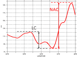
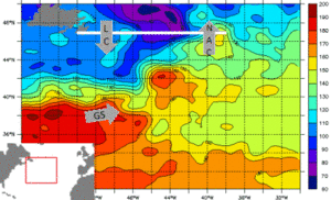
On the northern boundary of the Gulf Stream, where the subtropical and subpolar gyres meet together, the exchanges of heat are maximum. The Labrador Current (LC), belongs to the subpolar gyre, is a cold current which flows from the Arctic Ocean. Its constrasted meeting with the warmer waters, on the Great Bank off Newfounland, produces heavy banks of mist often feared by fishermen. These warmer waters belongs to the northern branch of the Gulf Stream, the North Atlantic Current (NAC).
Along a longitudinal section, at the northern border of the Gulf Stream (47°N), the contrast between the LC and the NAC is easily shown with the dynamic topography heights: a jump of more one meter is observed between 43°W and 39°W, on 2008/11/19.
Further information :
- Gulf Stream and Kuroshio as seen by altimetry on Google Earth (Download the kml file and open it in Google Earth).
- Image of the month, January 2005 : Current heat.
- Lively Data, June 17, 2005 : Kuroshio and Gulf Stream.
- Lively Data, August 17, 2005 : The seasons of the Gulf Stream.
- Lively Data, December 2009: On the borders of the Gulf Stream.
- Newsletter #4, 1996: Predictions of the Gulf Stream assessed with Topex/Poseidon data
- Gulf Stream predictions assessed with TOPEX/POSEIDON data external website, Radar Altimetry Tutorial, data use case : Western boundary currents: The Gulf Stream and its seasonal variations.
- K. Kelly et al., 2009: The Gulf Stream, Conveyor or switch? (pdf from the OSTST in Seattle).
![]() Use the Live Access Server
Use the Live Access Server


