SWOT DATA CHALLENGE NATL60 - 2020a_SSH_mapping_NATL60
Types of dataset: multimission simulation products.
Contents: SWOTsimulator along-track nadir and wide-swath altimeter SSH products with and without simulated noise content; reference ocean general circulation model (OGCM) simulation
DOI: 10.24400/527896/a01-2020.002 - more metadata
Use: regional studies; ocean variability (mesoscale circulation), data challenge. For example, it will allow investigating the performance of mapping algorithms with recent and future altimeters constellation, and/or assessing the performances of altimetric missions not currently in orbit (like SWOT mission).
Condition of access: The 2020A_SSH_MAPPING_NATL60 products are available free of charge for any project or study.
Data access service: OpenDap
Citation: Publications should include the following statement in the Acknowledgments:
“The data used in this study (DOI: 10.24400/527896/a01-2020.002) were developed, validated by CLS and MEOM Team from IGE (CNRS-UGA-IRD-G-INP), France and distributed by Aviso+”.
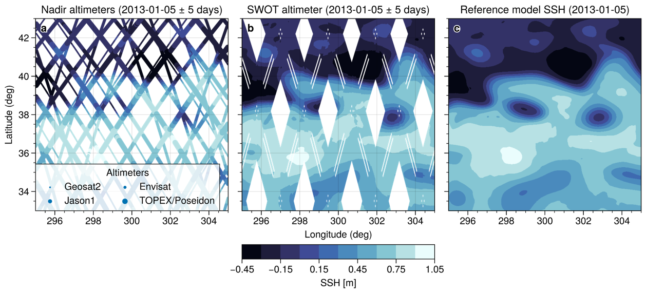
Description: Following the Observation System Simulation Experiment (OSSE) framework, the SSH observations include simulations of Topex-Poseidon, Jason 1, Geosat Follow On, Envisat, and SWOT altimeter data. There are along-track products for each mission and a gridded product extracted from a realistic high-resolution ocean simulation NATL60-CJM165 ([1], [2]). This processing step is carried out with the SWOTsimulator ([3], [4]).
Geographic coverage: Gulf Stream [65°W-55°W][33°N-43°N]
Format: NetCDF-4 Classic with CF standards.
Tools:
- User Handbook
- Code delivery: the open source code is available at https://github.com/ocean-data-challenges/2020a_SSH_mapping_NATL60
References:
[1] The reference simulation is the NATL60 simulation based on the NEMO model (Ajayi et al. 2020, DOI: 10.1029/2019JC015827). The simulation is run without tidal forcing.
[2] https://github.com/meom-configurations/NATL60-CJM165
[3] L. Gaultier, C. Ubelmann, and L.-L. Fu, “The challenge of using future SWOT data for oceanic field reconstruction,” J. Atmos. Ocean. Technol., vol. 33, pp. 119–126, Jan. 2016, DOI: 10.1175/JTECH-D-15-0160.1
[4] https://github.com/SWOTsimulator/swotsimulator
Copyright : 2020 CLS - Cnes / ANR
SWOT data challenge NATL60 dataset
Satellite | Authenticated access service | Data period |
|---|---|---|
| Simulated Along-track Topex/Poseidon |
Accessible via your personal MY AVISO+ | 2012/10/01-2013/09/29 |
| Simulated Along-track Jason-1 | 2012/10/01-2013/09/29 | |
| Simulated Along-track Geosat Follow On | 2012/10/01-2013/09/14 | |
| Simulated Along-track Envisat | 2012/10/01-2013/09/30 | |
| Simulated Along-track SWOT | 2012/10/02-2013/09/30 | |
| Reference simulation (NATL60-CJM165) Gridded | 2012/10/02-2013/09/30 |

