Measuring waves... with waves
Image of the month - December 1999
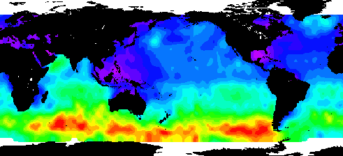
Spaceborne altimeters measure sea surface height first and foremost, but we can also obtain other physical parameters using satellite altimetry techniques. One such example is wave height, which is of prime importance to marine weather forecasters and ships at sea (see wind and waves applications).
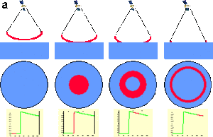
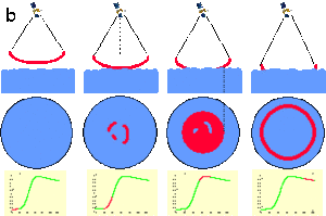
We can derive wave height by looking at how the sea surface reflects the radar signal. The radar altimeter receives the reflected wave (or echo), which varies in intensity over time. Where the sea surface is flat (a), the reflected wave's amplitude increases sharply from the moment the leading edge of the radar signal strikes the surface. However, in sea swell or rough seas (b), the wave strikes the crest of one wave and then a series of other crests which cause the reflected wave's amplitude to increase more gradually. We can derive ocean wave height from the information in this reflected wave, since the slope of the curve representing its amplitude over time is proportional to wave height.
See also:
- Applications : Winds and waves
- Why satellite altimetry ?
Websites on this subject:
- What are waves?
- Marine Meteorology

