A turbulent sea
Image of the Month - May 1999
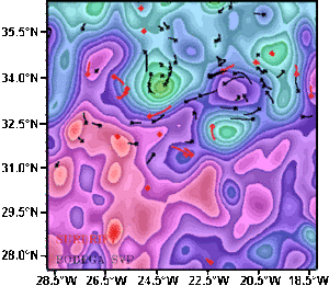
Dynamic sea surface heights forecast at 125 meters for 10/28/93 (from Soap model) and buoys tracked around the Azores (lines show Surdrift and Bodega buoy tracks over three days, squares show where they were released). The figure reveals how the buoys drift with the ocean currents, which circulate in a clockwise (anticyclonic) direction around the hills (in mauve) and in a counter-clockwise direction (in green) around the valleys.See animation (472 Kb).
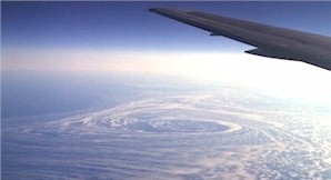
A cyclonic eddy off the coasts of Labrador. This eddy, branched of the Labrador Current can be seen due to the sea ice it carries.
(Credits E. Dombrowsky)
Ocean currents are sometimes compared to "sea highways", because ships follow their flow to gain speed. But this picture is not wholly accurate. In fact, ocean currents are more like secondary roads branching off into narrow country roads and lanes, winding their way around the hills and natural obstacles. For example, the main flow of these currents is often perturbed by eddies that form at their edge. These swirling eddies can often be as much as 300 kilometers across. The same kind of phenomenon is seen in rivers where the flow encounters an obstruction, such as a bridge for example, where eddies form downstream of the piers. In the same way, water eddies around the hills and valleys of the ocean surface. So the ocean is really more like a vast, slowly swirling whirlpool bath than a swimming pool divided into perfectly straight lanes.
Modern oceanography is concerned with forecasting ocean currents and their meanders and eddies. The Soap model and its successor Soprane, developed at Shom, the French Navy's hydrography and oceanography department, are the first steps on the road to truly global ocean forecasting.
See also:
- Applications: Ocean circulation and its variations
- Applications: Operational applications
Websites on this subject:
- Altimetry and eddies
Topex/Poseidon website at JPL - Picture of eddies
Oceanography from the space shuttle

