Mare nostrum, Mare incognita?
Image of the Month - September 1999
Ever since ancient times, the Mediterranean Sea has occupied a vital place in the lives of the peoples on its shores.
It is also a sea of mystery. According to the myths of Ulysses and Jason, the Greeks' voyages of adventure took them to the four corners of the Mediterranean, from the Pillars of Hercules in the west (Gibraltar) to Hellespont in the east (Dardanelles). In later years the Mediterranean linked the various parts of the vast Roman Empire. Indeed, such was the Romans' dominance on all sides of the Mediterranean basin that they called it "our sea" (Mare Nostrum). And it was here that Orient met Occident as Islam and Christianity fought to wrest this strategic prize from each other's grasp. Today, it is one of the world's main commercial routes.
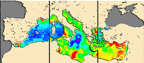
Despite its importance to the economy, ecology and tourism, the Mediterranean is still poorly understood. Oceanography programs have been set up to study its movements and its fragile ecosystem. These programs rely on satellite observations of altimetry, sea surface temperature and ocean color, merging a wealth data to piece together the Mediterranean puzzle. Ocean color measured in the visible spectrum indicates levels of phytoplankton in the ocean and thus tells us about biological conditions. Radar altimetry allows us to penetrate clouds and haze to measure sea surface height, which reflects the dynamic topography from the ocean floor to the surface. Lastly, sea surface temperature detected in the infrared range reveals the extent of ocean-atmosphere heat exchanges.
See also:
- Image of the month, January 2006 : Merging of altimetry data: proofs from other measurements
- Satellites Monitor The Mediterranean Pulse (pdf, 3.3 Mb).
Websites on this subject:
- Altimetry in the Mediterranean Sea
- Mediterranean seen by Topex/Poseidon (by kids from a primary school, Cerga) (in french)
- Variabilities in the Mediterranean (Cerga) (in french)
- MATER (CLS)
- Ocean Color in the Mediterranean Sea
- Ocean Color From Space (GSFC/Nasa)
- Données CZCS (SeaWifs website)
- Sea Surface Temperature in the Mediterranean Sea
- Seasonal SST variations (German Remote Sensing Data Center - DFD) (in english or german)
- SST and winds (Rosenstiel School of Marine and Atmospheric Science)
- Test Case: Mediterranean Sea (ISAO/EuroGoos)

