Focusing on small water bodies
Image of the Month - March 2019
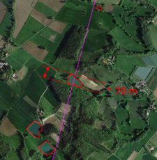
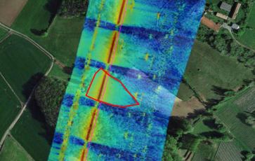
A pond as seen by optical satellites (left); right, the fully-focused SAR measurements of it (note that the repetitions are due to the emission/reception pattern of the altimeter which leads to secondary images; Jason-CS/Sentinel-6 interleaved emission/reception pattern should remove those) (Credits CLS)
The SAR-altimetry mode (or Delay-Doppler altimetry) is implemented on Cryosat, the Sentinel-3A & B and in the future on Jason-CS/Sentinel-6 and the Sentinel-3 C& D. This mode enable to get higher along-track resolution at a better accuracy (see Technique > Altimetry > SAR altimetry), and is more and more used, in particular for inland water applications.
The currently SAR altimeters processing uses coherent altimeter radar echoes over a limited time (approximately 3.52 ms). However, the entire illumination time of the surface (almost 2.5 s) can be used for the synthetic aperture processing since it stays coherent for that entire period. This, called “Fully-focused SAR processing” thus achieves better along-track resolution, eventually reaching the theoretical limit of approximately 50 cm for current SAR altimeters (which is half the diameter of the antenna).
With such a finer resolution, very small water bodies crossed by the satellite ground track can be accurately observed and measured. The fully-focused SAR processing can be applied to the three currently flying SAR altimeters (CryoSat-2, Sentinel-3A & B) and also to the upcoming SAR altimeters (Sentinel-3C & D and Jason-CS/Sentinel-6). Jason-CS/Sentinel-6 should show even greater performance thanks to the interleaved mode planned on this mission, which will emit and receive the altimeter echoes alternatively, instead of emitting 256 times then going on receiving mode for a period, and so on (this latter mode have the drawback of generating "ghost" measurements in fully-focused SAR processing, duplicating the results further along the track if not taken into account)
Those altimeters having different ground tracks, a huge dataset of water levels will be studied for itself, and will also be used in combination/comparison with Swot data when the satellite will be flying. Studies on ice, coasts and even open ocean are also ongoing.
See also:
- Applications: High-resolution hydrology
- Techniques: Delay-Doppler / SAR altimetry
- Missions: Cryosat, Sentinel-3A & Sentinel-3B
References:
- Rieu, P., T. Moreau, L. Amarouche, P. Thibaut, F. Boy, S. Le Gac, N. Picot, F. Borde, C. Mavrocordatos, 2018: From unfocused to fully focused SAR processing: illustrations of potential benefits for different surfaces, OSTST 2018 meeting, Ponta Delgada, Portugal, Sept. 2018

