Liguro-Provençal current seen by in situ instruments and altimetry
Image of the Month - May 2019
Satellite altimetry has brought a wealth of new information on open ocean currents. Coastal currents with their small-scale structures and their dynamics (especially in the Mediterranean Sea), if hard to monitor by altimetry alone, can be studied by combining it with other, complementarity, techniques.
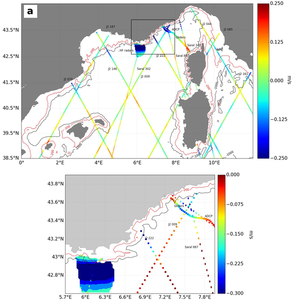
Among the available techniques used on the North-Western current of the Mediterranean (Liguro-provençal current), one can list altimetry, but also high-frequency radars, Acoustic Doppler current profiler (ADCP) and gliders. Along-track altimetry with a dedicated coastal processing provides reasonably good monitoring of surface currents in both space and time, but its effective spatial resolution does not allow to resolve all the mesoscale and sub-mesoscale signals associated with a coastal current. The High-Frequency coastal radars provide a good daily view of the water surface but only for a small area (60 x 40 km) and, as they observe only the surface layer, they may measure mostly a strong wind-driven current (Ekman flow). Acoustic Doppler current profiler (ADCP) aboard a ship allows to see a vertical current structure at very high resolution and up to the coast, but it is irregularly sampled and the measurements may contain unsteady ageostrophic current components such as inertial oscillations. Gliders have lower horizontal resolution and temporal sampling than ADCPs and HF radars, but they provide much longer sections of observations.
All in all, the study on the Liguro-provençal current shows that the four sources of data provide different current estimates but with a general coherency. This also helps in the quantification of the current components: altimetry alone tends to underestimate the current. A multidata combined approach is a unique way to obtain a complete picture of a dynamical system as complex as the Liguro-provençal current. Finally, it is important to note that improved altimetry data processing and corrections as well as technical innovations lead to an ever increasing number of coastal data points ever closer to the coastline.
See also:
- Data: X-Track SLA regional data (Mediterranean Sea)
- Applications: Mediterranean Sea
- image of the Month, September 2006: Mediterranean currents
- image of the Month, October 2014: Better Mediterranean circulation
- image of the Month, June 2015: Current intruding on the continental shelf
References:
- Carret, A., Birol F., Estournel C., Zakardjian B., Testor P.: Synergy between in situ and altimetry data to observe and study Northern Current variations (NW Mediterranean Sea), Ocean Sci., 15, 269-290, https://doi.org/10.5194/os-15-269-2019, 2019

