SGDR+ Ice Sheet products
Types of dataset: Along-track SGDR+ Ice Sheet product for SARAL/AltiKa mission.
DOI: 10.24400/527896/a01-2022.004 - more metadata
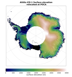
Contents: Along-track Altimetric product. All fields available in the SGDR are also available in the SGDR+ IceSheet product, with extra fields added to the product, the major added-value is a dedicated slope correction, using a relocation method of the altimetry measurement.
Use: This product was designed to provide additional and valuable data over the Antarctica & Greenland ice sheets, to fulfil user requirements.
Condition of access: These products are standard as detailed in the licence agreement. Users should keep in mind that these products are experimental products. Notably, they are not produced on an operational basis. They are freely distributed without any warranty of any kind.
Description: SGDR+ Ice Seet products are available on one year (Oct 2018 to Nov 2019) for SARAL/AltiKa mission. It contains additional variables such as ice sheet elevation, a dedicated slope correction, using a relocation method of the altimetry measurement in order to deliver a product dedicated to ice sheet surfaces. SARAL orbit covers high latitudes up to +/-81.5°, providing valuable information of the Earth’s polar cryosphere. More information in the AVISO+ Newletter.
Geographic coverage: Antarctica and Greenland ice sheets.
Data access service: FTP, TDS
Format: NetCDF-3 Classic.
Tools: SGDR+ Ice Sheet SARAL product User Handbook
Citation: Publications should include the following statement in the Acknowledgments:
"Those products were processed in the frame of the CNES Alti-Glacio project and distributed by AVISO+ (https://www.aviso.altimetry.fr)”
Copyright: 2018 - 2019 Cnes/Cls.
Altimetry SGDR+ Ice Sheet product
Satellite | Authenticated access service | Content | Data period | File weight |
|---|---|---|---|---|
| SARAL/AltiKa | Available via your personal space: MY AVISO+ | one file per pass | Oct 2018 to Nov 2019 | <25 MB (zipped file) |


