SSALTO/DUACS Experimental products including CFOSat for wave-current interactions studies
Types of dataset: SSALTO/DUACS multimission "Experimental" products of geostrophic velocities and Sea level anomalies.
DOI: 10.24400/527896/a01-2023.001 - more metadata
Contents: Version 2.0 of the product is available. 3 datasets are proposed 1/ along-track L3 across-track geostrophic velocities (from sea level anomaly and absolute dynamic topography) filtered at 15 and 60 km, with angle values (giving the positive across-track direction) of CFOSat mission, 2/ gridded L4 sea level anomalies and geostrophic velocities from 8 merged missions including CFOSat (Sentinel-6, Jason-3, Sentinel-3A, Sentinel-3B, Altika, Cryosat, HY2B, CFOSat) 3/ gridded L4 Sea level anomalies and geostrophic velocities from 7 merged missions without CFOsat (Sentinel-6, Jason-3, Sentinel-3A, Sentinel-3B, Altika, Cryosat, HY2B).
Use: wave-current interactions
Condition of access: Users should keep in mind that these products are experimental products. Notably, they are not produced on an operational basis.
Citation: When using those experimental products, please cite: "Those products were processed by SALP and distributed by AVISO+ (https://www.aviso.altimetry.fr) with support from CNES (https://doi.org/10.24400/527896/a01-2023.001)”
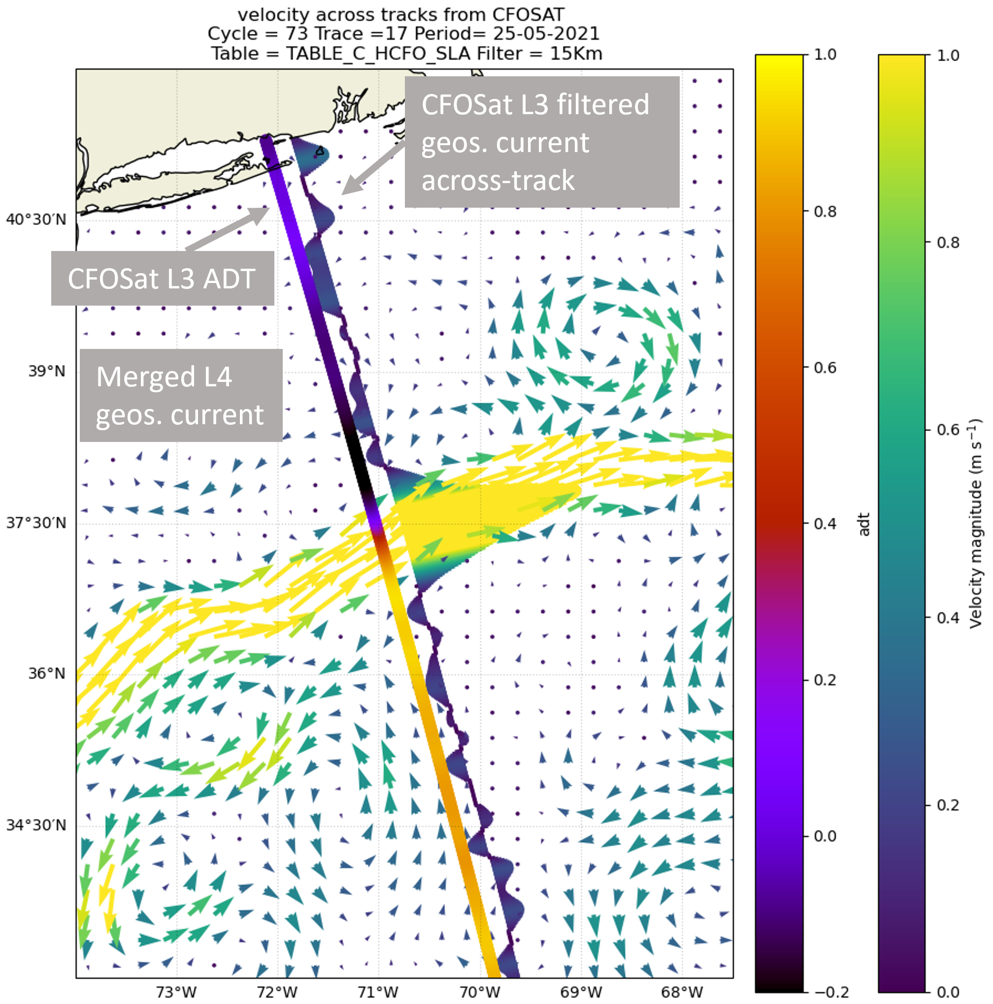
Description:
- The CFOsat sea level measurements used to calculate the L3 and L4 products were processed using the latest version of CFOsat processing (Tourain et al., 2023) with a specific SSB (Sea State Bias) correction using the contribution of diffusiometric measurements of wave spectra. Editing adapted to 5Hz and slackened on strong waves has made it possible to clean up anomaly data while retaining as much usable data as possible. The SLA is filtered at 1000km to retain only the high-frequency input from CFOSAT. Low frequencies are replaced by the mean sea level calculated at L3 level, combining all satellites.
- For the L4 products, the geostrophic current is derivated from sea level anomaly maps generated with MIOST multiscale and multivariate mapping tool (Ballarotta et al., 2023) with level 3 altimetric data (except for CFOSat) distributed by the EU Copernicus Marine Service (product SEALEVEL_GLO_PHY_L3_MY_008_062, https://doi.org/10.48670/moi-00146). Details in Jenn-Alet & al., OSTST 2023
Geographic coverage: global
Format: NetCDF
References:
- Tourain C., L Hermozo, Danièle Hauser, L Aouf, C Peureux, et al.. CFOSAT: Products Reprocessing and Contributions in Oceanography. IGARSS 2023 International Geoscience and Remote Sensing Symposium, IEEE, Jul 2023, Pasadena, CA, United States. pp.3958-3961, (https://doi.org/10.1109/IGARSS52108.2023.10283105). (hal-04180798)
- Ballarotta, M., Ubelmann, C., Veillard, P., Prandi, P., Etienne, H., Mulet, S., Faugère, Y., Dibarboure, G., Morrow, R., and Picot, N.: Improved global sea surface height and current maps from remote sensing and in situ observations, Earth Syst. Sci. Data, 15, 295–315, https://doi.org/10.5194/essd-15-295-2023 , 2023
- Jenn--Alet & al., OSTST 2023, CFOSAT Sea level and current demonstration products
- Faugère et al., OSTST 2022, CFOSAT Sea level and current demonstration products, DOI: 10.24400/527896/a03-2022.3602
Copyright : 2019-2023 CLS/Cnes
SSALTO/DUACS Experimental products including CFOSat for wave current interactions studies
| Products | Version | Area | Type | Authenticated access service | Data period | File weight |
|---|---|---|---|---|---|---|
| L3 CFOSat product | 2.0 | Global | along-track filtered at 15 and 60 km | please refer to MY AVISO+ and select the product "Ssalto/Duacs Experimental products: along-track and gridded Sea Level Heights and velocities" | 2019/05/19 – 2023/03/06 | 560 Kb |
| L4 including CFOSat product 8 missions | gridded | 12 Mb | ||||
| L4 without CFOSat product 7 Missions | ||||||
| L3 CFOSat product | 1.0 | Global | along-track filtered at 45 and 60 km | No more available (only on demand at aviso@altimetry.fr) | 01/01/2021 - 31/12/2021 | - |
L4 including CFOSat product | gridded | 01/01/2021 - 31/12/2021 | - | |||
L4 without CFOSat product |

