Scaling the waves
Image of the month - September 2003
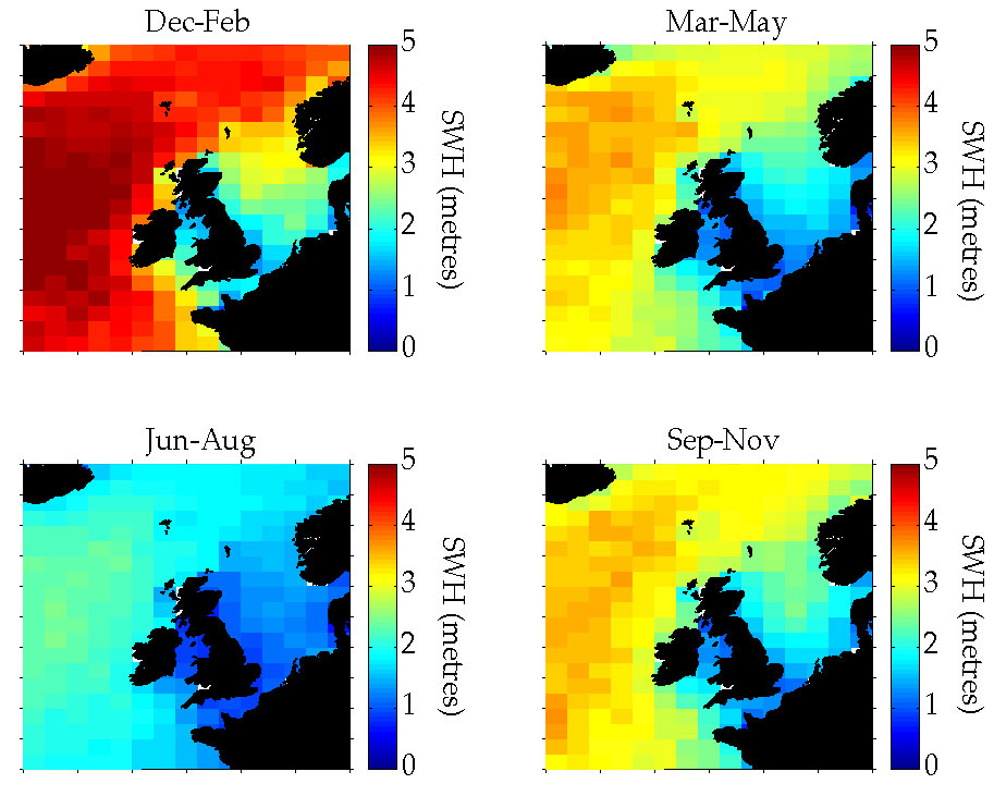


 | Mean wave heights from altimetry off the British Isles for the years 1993-97, in winter (December-February), spring (March-May), summer (June-August) and fall (September-October). The seasons are very well marked to the west of the Isles, with rough winters -identified by wave heights that can reach 14 meters and even as high as 20 meters, and calm summers. (Credits Southampton Oceanography Center) |
Big waves are fun - for surfers. For seafarers, coastal equipment designers and inhabitants, they are potential dangers that have to be taken into consideration. Altimetry cannot give the wave heights every hour - at least not without many many more satellites, but it is a good technique for identifying trends and gives us some idea of the minimum and maximum heights.
The North Atlantic may not be the roughest part of the ocean (which is in fact the Southern Ocean), but it does have the most marked variations, and its coasts are quite populated. The British Isles, along with Brittany, bear the brunt of ocean storms so potential damage has to be assessed.
See also:
- Image of the Month, May 2001: North Atlantic Oscillation makes waves
- Image of the Month, December 1999: Measuring waves... with waves
- Applications: Winds and waves, marine meteorology
Websites on this subject:
- Wave studies (Southampton OCeanography Center)
- Waves and tides (US Navy)
References:
- Woolf, D.K., P.D. Cotton and P.G. Challenor, 2003: Measurements of the offshore wave climate around the British Isles by satellite altimeter. Philosophical Transactions: Mathematical, Physical & Engineering Sciences, 361(1802), 27-31, DOI: 10.1098/rsta.2002.1103

