Ocean circulation with gravity
Image of the month - May 2004
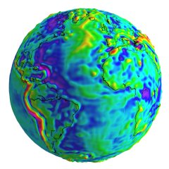
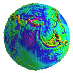
Gravity field is important for any satellite -- it's where they move, and what determine their trajectory. But with altimetry satellites like Jason-1, Topex/Poseidon or Envisat, gravity field measurements take a special importance -- or more precisely, measurement of its effect on the ocean, a.k.a. the geoid. First, becausebetter knowledge of the gravity field means a better orbit, and thus a better sea level height precision (see Altimetry: How altimetry works). And also, since sea surface height is the sum of geoid height and ocean circulation height (which comprises a permanent stationary component and a highly variable component). In practice, the geoid is not yet known accurately enough, and thus absolute ocean circulation is difficult to estimate (the variable part of the ocean signal -- the Sea Level Anomalies -- are computed intead). Champ, Grace and soon Goce missions should improve measurements of the geoid, and thus knowledge of the ocean circulation. Already, Champ et Grace brought improvements (see Image of the Month for February 2003: Ocean currents ).
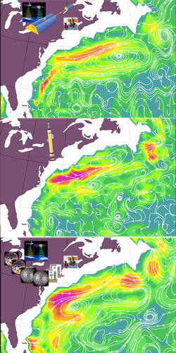
Ocean currents in the Gulf Stream region, 1000 m beneath the surface. Top, from the Grace geoid, satellite altimetry, and ship measurements. The bottom panel only differs from the top one in the fact that the best geoid prior to Grace launch is used there. The middle panel shows direct measurement of those currents by floats deployed from ships, for comparison. (Credits CSR)
See also:
- Applications: Geophysics
- Data: Precise Orbit Determination
Websites on this subject:
- Champ (GFZ)
- Grace website (GFZ), Grace website (CSR)
- Goce (Esa)

