Four satellites to watch over the Mediterranean
Image of the month - September 2004

The Mediterranean Sea has rugged coasts, indented in several seas --Adriatic, Egean, Alboran... -- that imply high resolution measurements for its complete observation. It is also a much populated area, with many people living along its coastline, and a nearly enclosed sea with a fragile ecosystem. A better knowledge of this sea is thus a major stake of the people living there.
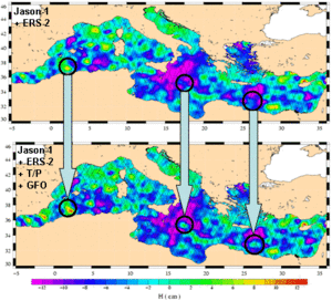
With four altimetric satellites now available (Jason-1, Envisat or ERS-2, Topex/Poseidon and GFO), resolution of sea surface height measurements is greatly enhanced. Three satellites at least are needed to observe eddies and mesoscale phenomenon in the Mediterranean. However, the continuity of such a constellation of satellites is far from sure, with only Jason-2 being decided till 2012.


Mean Eddy Kinetic Energy in the Mediterranean, as seen by Jason-1 (top) and by Jason-1+ERS-2+T/P+GFO (bottom). Quantity of observed kinetic energy is higher, and shows more details with the combination of satellites. (Credits MFS/CLS)
See also:
- Data products: Ssalto/Duacs (Data Unification and Altimeter Combination System)
- Altimetry: Multiple satellite for high-precision altimetry
- Applications: Mediterranean Sea


