A dual-frequency view of Antarctica
Image of the month - November 2004
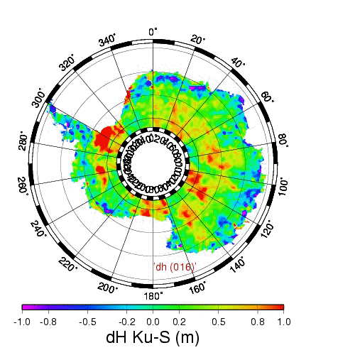
Difference between Envisat altimeter (RA2) measurements in Ku band (13.6 GHz) and S band (3.2 GHz) in April (Southern autumn). This difference changes with the seasons, due to temperature and/or precipitations and wind changes (click to see the animation over one year, one image every month from April 2003 to March 2004) (Credits Legos)
Antarctica and Greenland glacier study have a particular importance since their reactions is one of the major unknown of global warming scenarios. Altimetry measures iced surface topography and the speed of ice flow (see the Images of the Month for April and August 2000, Rivers of ice in Antarctica and A lake capped by ice). With altimeters that operate at two frequencies (initially to correct the altimetric measurements), it shows also the difference of penetration of radar waves inside the Antarctic snow-pack, which changes over time. Yet to be explained completely, this difference has to do either with changes in absorption, which would follow the annual temperature cycle, or with changes in scattering, which would follow the annual precipitation/wind cycle.
Envisat, with its high latitude orbit (up to 82° North and South) is especially interesting for Antarctica observation, since it covers most of this continent. With all its intruments onboard, it can moreover look at the same phenomenon under different views, and thus precious information can be retreived.
See also:
- Applications: Ice
- Image of the Month: April 2000, Rivers of ice in Antarctica
- Image of the Month: August 2000, A lake capped by ice

