The 2015 El Niño: An extraordinary Modoki event?
Image of the Month - January 2016
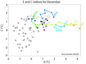
(left) Evolution of the E (“Eastern Pacific”) and C (“Central Pacific”) indexes as defined in Takahashi et al. [2011] for December for the 1954-2015 period. Data are from SST Reanalysis ERSSTv3. The evolution over 6 months prior to December is also displayed in color for 5 El Niño events: 1972 (light blue), 1982 (yellow), 1997 (orange), 2009 (green) and 2015 (blue). The purple dots with dates indicate other El Niño years.
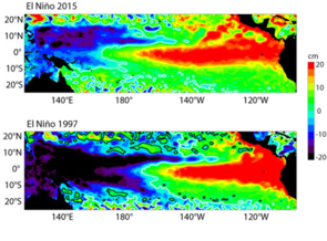
(right) sea level anomalies (in cm) in December for the 1997 and 2015 El Niño events. (Credits Legos)
It has been 18 years since the tropical Pacific experienced a strong El Niño event. The community has been since then scrutinizing the conditions in the Pacific. The developing warm conditions of 2015 have been mimicking what happened in 1997, the strongest events on record since the beginning of the 20th century.
However, since 1997, a number of observations and progresses in El Niño knowledge have been made. We know, now, that all El Niños are not the same: some (the extreme ones) are reaching the Americas’s coasts, other (mostly moderate) have their peak Sea Surface Temperature (SST) anomalies remaining in the middle of the Pacific. The Modoki El Niño events belong to the latter group.
Recently Takahashi et al. [2011] proposed two independent indexes to characterize this variety of phenomena. Plotted one against the other, those two indexes show the different evolution of events. The evolution towards large value of E (E like “Eastern Pacific”) would indicate a strong warming of the Eastern Pacific, including the Peru/Chile upwelling system, as during the 1997 El Niño (orange line), whereas a strong value on the C axis (C like “Central Pacific”), would indicate an El Niño event evolving like a Modoki El Niño event,as in 2009 (green line on the figure).
At the beginning of 2015, the 2015 El Niño was suspected to evolve as an extreme Eastern Pacific event due to a significant warming of the Eastern Pacific. However the anomalous conditions have grown more in the Central Pacific than near the coast of Ecuador and Peru, bringing this on-going event in the category of an extraordinary Modoki event. In particular, the C index has reached unprecedented values for September and November and the warm pool (region with SST higher than 28°C) has remained confined to the western-central Pacific, conversely to the 1997 El Niño event. In December 2015, sea level anomalies have reached positive anomalies as high as during the 1997 El Niño in the eastern Pacific. However the positive sea level anomalies extend further to the west.
See also:
- Image of the Month, Nov. 2009: If it's not El Niño, then it must be his brother...
- Data/Ocean indicators: El Niño bulletin
- Applications: El Niño
- Diagram and map plotting: Live Access Server
References
- Takahashi, K., A. Montecinos, K. Goubanova, and B. Dewitte (2011), ENSO regimes: Reinterpreting the canonical and Modoki El Niño, Geophys. Res. Lett., 38, L10704, doi:10.1029/2011GL047364.


