Storm in the Bay of Biscay
Image of the Month - March 2016
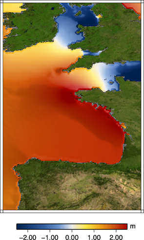
Tidal height at 5 AM on Feb. 11, 2016 (left) and sea level anomalies uncorrected from both tides and atmospheric pressure from Saral. Saral flew a bit off the Aquitaine coasts on February 11, 2016 at high tide, a day when Bordeaux quays were flooded. If we look at Sea level anomalies uncorrected from tides and from atmospheric pressure, and compare it to the same track 35 days earlier (previous cycle), we see a difference of about 3 metres (mostly due to tides, but not only). This gives an indication of what could have happened up the river at Bordeaux (adding heavy rains, too, flowing down the river) (Credits Aviso)
A series of storms stroke French Atlantic coasts beginning of February 2016. During one of those, the quays of Bordeaux were flooded. The city of Bordeaux is not on the coasts but near enough from the ocean on the Garonne river that it is subject to tides and other ocean influences. These latter include the fact that low atmospheric pressures (as seen during storms) mean a higher sea surface height, since the atmosphere weights less on the ocean waters. Moreover, the river can also rise due to rains (or snow melt).
Storm surges, or at least high water levels during storms are the main reason for coastal flooding. When you add the effects from low pressure, high tides, and winds blowing from the sea to the land, the water level can rise higher than usual, sometimes dramatically so.
Altimetry in coastal areas is the subject of many studies, and the data are improving constantly. Waiting for Swot and its high resolution, we can already measure such phenomena a little off the coasts, and modelize what happens.
See also:
- Applications: Wind and Waves
- Applications: ocean tides
- News: Xynthia
- Data: Saral Geophysical Data Records
- Data: tide models

