It's raining under Jason-3
Image of the Month - August 2016
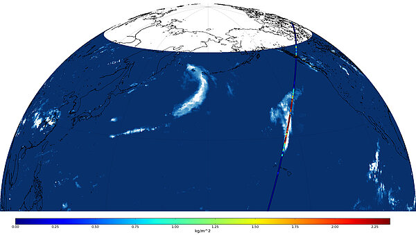
Launched a little more than 6 months ago, Jason-3 is still undergoing validation phase. During these first months of the satellite life the "CalVal" teams are looking closely at anything looking slightly strange, even more than they normally do during the operational phase of a satellite. And the data for April 5, 2016 had this high increase in cloud liquid water content (computed from the onboard AMR radiometer). A cross-check with other data, firstly the altimeter ones, then external data from another satellite gave the solution: this was no anomalous data, just a big rain cell which Jason-3 flew over.
The radiometer onboard the altimetry satellites enable to correct and/or flag the data from different atmospheric perturbations. Those could affect the altimeter radar wave in its travel back and forth from the satellite. Measuring them thus ables to estimate the sea surface heights with the highest possible accuracy.
The CalVal teams are doing the quality control of all processed data, publishing regular reports on every cycle for operational missions, trying and understanding every glitch in the data in order to always provide users with the best quality altimetry measurements. They are an important part of any altimetry "mission" - a term which includes the satellite but also all the ground teams who work for the data to exist, be controlled and disseminated.
See also:
- Applications: Atmosphere, wind and waves
- Data: Calval
- Missions: Jason-3
- Image of the Month, June 2005: Cloudy skies
- Image of the Month, March 2000: Raindrops keep falling on the sea
Other web sites on this subject:http://podaac.jpl.nasa.gov/
- PO.DAAC (NASA/JPL)

