As the flood flows
Image of the Month - June 2018
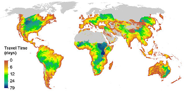
Satellite observations of floods are commonly used to assess damage, assist in emergency response, and help a region recover. These observations of floods also can be used for the preparation and prediction of future flood events. However, if a flood is observed upstream from a city or dam, it may be used in early flood warning systems to help a city or dam prepare for the approaching flood. The speed of a flood wave (or flow wave) can be estimated using computer models and this information can be critically important when big cities or dams are located downstream from an observed flood.
But for satellite observations of floods to be useful for these real-time applications, it must be made available to users with enough time for actions to be taken. In most cases, satellite data can't be made available to users instantly after their measurement - onboard data processing, downlinking to ground stations, further processing and upload to dissemination servers make it so that a given time is necessary between the measurement and when the data is available. Currently, altimetry data are provided with 2 hours, 2 days or 2 months latency, with the longer delays corresponding to more data accuracy. Hydrologic monitoring systems usually use a 2 day latency. Is this a short enough latency for upstream flood observations to be useful to downstream cities an dams?
SWOT is not planned as an operational mission, but a low-latency product may be useful for users for real-time applications. This product can be used to assess the impact of the mission - and of potential follow-ons. A recent study demonstrates that a 2-day or 3-day data latency SWOT product could be useful for real-time river flood mitigation applications, at least in the majority of cities and dams worldwide.
See also:
- Applications: High-resolution hydrology
- Missions: Swot
Other websites on this topic:
- river and lake levels by altimetry in near-real time on Hydroweb and Copernicus Global Land
References:
- Allen, G. H., David, C. H., Andreadis, K. M., Hossain, F., & Famiglietti, J. S. (2018). Global estimates of river flow wave travel times and implications for low‐latency satellite data. Geophysical Research Letters, 45. https://doi.org/10.1029/2018GL077914

