Flash flood at the Têt river mouth
Image of the Month - March 2018
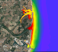
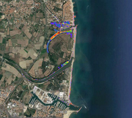
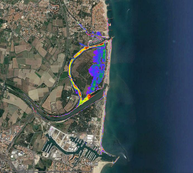
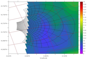
Several outputs from the high resolution Symphony model, taking different parameters into account: left, the impact of waves on the coast, middle a 20-cm error on the sea level estimate, right a strong river discharge (and the sandbar at the mouth of the river). The Canet seaside resort is more or less impacted depending on the parameters included in the model (Credits Aerology Laboratory Toulouse)
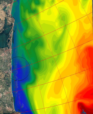
On the Roussillon coast of France (West of the Gulf of Lion, North of the Iberic peninsula border on the Mediterranean Sea) several rivers flow into the sea. Those rivers (the Agly, Têt and Tech) come from the Pyrenees mountains and tend to undergo flash flood episodes during Winter storms but also Summer thunderstorms. During Winter storms, though, you can also have high waves, low pressure, strong winds adding to the phenomena. Modelling such phenomena at the rivers' mouth is important to help mitigate effects, build appropriate infrastructures and keep inhabitants informed.
With Swot, the altimetry measurements used for the models will be more coastal, and over an number of rivers too, with high resolution and more revisit over an area. It won't enable to see the flash floods and their immediate consequences when they occur most of the time probably, but it will help understand and forecast better their spread and impacts on the river banks, mouths and on the coasts nearby.
See also:
Reference:
- Michaud H., Marsaleix P., Leredde Y., Estournel C., Bourrin F., Lyard F., Mayet C., Ardhuin F., 2012. Three-dimensional modelling of wave-induced current from the surf zone to the inner shelf. Ocean Science, 8, 657-681, http://dx.doi.org/10.5194/os-8-657-2012

