Sea ice leads by two Sentinels
Image of the Month - April 2018
Arctic is one of the less-known region, and an area where climate change impacts are the most extreme. Satellites are one of the easiest means of exploring this harsh region, with now a wide range of techniques enabling to see the same phenomena with different 'eyes'. The EU Sentinel satellites are an important part of this monitoring, with very soon a new Sentinel-3 (Sentinel-3B) to be launched, and already two Sentinel-1 (Synthetic Aperture Radars), two Sentinel-2 (optical imagery) flying.
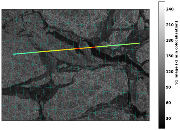
Among the parameters interesting to measure on sea ice, the ice thickness (related to freeboard, i.e. the height of the ice over the water level) provides information on ice age, melt or water freeze, etc. Knowing the fracture zones in sea ice (or "leads") is important for the correct estimate of this ice thickness from remote sensing. Detecting them can be done using either SAR (Sentinel-1) or altimetry (onboard Sentinel-3, but also Saral, Cryosat...).
SAR imagery leads detection uses the contrasts and roughness of the surrounding ice, while the detection from altimetry is based on the shape and amplitude of the return echoes (the waveforms). Depending on the surface hit, this echoes is e.g. more or less peaky. Here also, contrasts with the echoes before and after enable to detect those narrow leads in the ice. Both techniques and approaches provide with detections which are well correlated over Arctic.
With soon a second Sentinel-3, and in the future Jason-CS(Sentinel-6), also a pair of identical satellites, and a second pair of Sentinel-3, a denser mesh of altimetry measurements will help detecting more such features over a long period. The use of the "SAR"-mode onboard all those will also enable, with specific processings, to reach higher resolutions, thus detecting much narrower leads.
See also:
- Applications / sea ice: Saral freeboard maps
- Missions: Sentinel-3A & Sentinel-3B
References:
- N. Longépé, R. Vadaine, A. Guillot, JC. Poisson, Asssessment of the capabilities of S-1 and Altika for lead detection, Altimetry & glaciology Workshop, Toulouse 2017
- JC. Poisson, D. Hoang, P. Thibaut, F. Piras, A. Guillot, N. Picot, Traitement des échos SAR/Doppler Sentinel-3A sur glace de mer, Altimetry & glaciology Workshop, Toulouse 2017 (in French)
- Nicolas Longépé, Pierre Thibaut, Rodolphe Vadaine, Jean-Christophe Poisson, Amandine Guillot, Francois Boy, Nicolas Picot and Franck Borde, Comparative Evaluation of Sea Ice Lead Detection based on SAR imagery and Altimeter data, submitted to IEEE TGRS.

