On the sources of Agulhas Current
Lively Data: February 17, 2009

The delayed-time dataset has been updated in the LAS: further 6 months extend the dataset that it now comprised between 1992/10/14 and 2008/06/11.
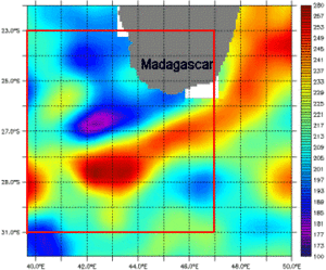
The Agulhas system is characterized by an intense mesoscale activity and was several times shown in our Lively data. We focus here on the source region of the Agulhas current which is well visible with maps of ADT and geostrophic currents, near the southern coasts of Madagascar.
The southern branch of the East Madagascar Current (SEMC) comes from the eastern side of the island and flowing toward SW. On the southwest of Madagascar, it is separated into two branches: the northern one will be linked westward to the Agulhas Current and the southerner branch will be retroflected eastward and will be connected to the Subtropical Indian Ocean Countercurrent (SICC). Choosing a favorable date (here the latest avaiblable date for the delayed-time data), the map of MADT and geostrophic current provide evidence of this area showing a major hill and valley which correspond to an anticyclonic (anticlockwise) and cyclonic (clockwise) motion respectively.
Further information:
- Applications, Ocean, Mesoscale circulation, Eddies around the world
- Lively Data,
- July 21, 2008: Steer due East around Antarctica
- May 09, 2007: About ocean variability
- December 21, 2006: Day by day, the Agulhas Current
- July 15, 2004: colors or contours
- June 30, 2003: South of Africa, currents and sea level heights
- Siedler, G., M. Rouault, A. Biastoch, B. Backeberg, C. J. C. Reason, and J. R. E. Lutjeharms 2009, Modes of the southern extension of the East Madagascar Current,J. Geophys. Res., 114, C01005, doi:10.1029/2008JC004921
![]() Use the Live Access Server
Use the Live Access Server


