DYNED Atlas
Atlas of 3D Eddies in the Mediterranean Sea from 2000 to 2019
Types of dataset: 3D product of multimission altimetry with colocalised T/S profiles from Argo floats.
DOI: 10.24400/527896/A01-2022.014
Contents: Contour and tracking of mesoscale eddies supported by the DYNED project: DYNED-Atlas . The eddies are derived from the Absolute Dynamic Topography (ADT) "all satellites" constellation maps version DT2018 (distributed by CMEMS). and their colocalised T/S profiles from Argo floats of the Coriolis data-base (http://www.coriolis.eu.org)
Use: Study of ocean mesoscale eddies
Condition of access: These products are available free of charge for any purpose (scientific, operational, commercial, etc.) as stated in the licence agreement.
Data access service: On FTP and Thredds Data Server via your personal space MY AVISO+
Description: Anticyclonic and Cyclonic eddies detected from the multimission altimetry and T/S profiles from Argo float datasets, with their location, contours, amplitude, radius speed and associated metadata, for the period: 2000/01/01 to 2019/12/31.
Geographic coverage: Mediterranean Sea
Format: NetCDF-4 Classic.
Tools and References:
- The list of the parameters included in the Atlas is described in DYNED_Atlas_Parameter_list
- The algorithm used is described in Le Vu, B., Stegner, A., & Arsouze, T. (2018). Angular Momentum Eddy Detection and Tracking Algorithm (AMEDA) and Its Application to Coastal Eddy Formation, Journal of Atmospheric and Oceanic Technology, 35(4), 739-762. https://doi.org/10.1175/JTECH-D-17-0010.1
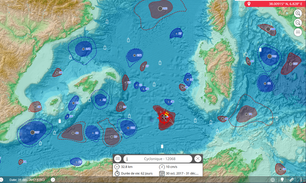
- A dynamic vizualisation tool is available here: https://dyned.cls.fr/seewater/
Citation: If you use the data, please cite: Stegner Alexandre, Le Vu Briac, Pegliasco Cori (2019). Atlas of 3D Eddies in the Mediterranean Sea from 2000 to 2019 [Data set] ESPRI/IPSL, distributed by Aviso+ https://doi.org/10.24400/527896/A01-2022.014
Copyright: 2000 - 2019
| to get access Aviso products and select the product "Mesoscale eddy trajectory atlas product" |
DYNED dataset
| Product | DOI | Authenticated access service | Data period | File weight |
|---|---|---|---|---|
| DYNED Atlas | 10.14768/2019130201.2 | see your MY AVISO+ | From Jan 2000 to December 2019 | 400 MB |

