Segmented images of meteocean processes
Types of dataset: monomission SAR Sentinel-1 images products.
DOI: 10.24400/527896/a01-2023.002 - more metadata
Contents: A thousand of manually annotated Sentinel-1 imagettes for learning applications
Use: deep learning, segmentation, SAR, oceanography, meteorology
Condition of access: These products are available free of charge for any purpose (scientific, operational, commercial, etc.) as stated in the licence agreement. Users should keep in mind that these products are experimental products. Notably, they are not produced on an operational basis.
Data access service: FTP
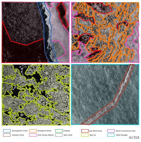
Description: This data set contains 1000 annotated imagettes (20x20 km approx.) of Sentinel-1 Wave Mode acquisition in the form of JSON polygons among 10 metocean features down to 50 meters resolution typically (see illustration) :
Atmospheric Fronts
Biological Slicks
Iceberg
Low Wind Area
Micro-Convective Cells
Oceanic Front
Pure Ocean Waves
Rain Cells
Sea-Ice
Wind Streaks
The present data set extends TenGeoP categorization (1 feature per imagette) to pixel-level segmentation among all 10 features listed above. Its main goal is the training of Deep Learning segmenters, with applications in automatic mapping of ocean surface processes [1] and in understanding air-sea interactions. A Jupyter notebook is provided in the dataset archive to consult the annotation. Raw Sentinel-1 sea surface roughness images in this dataset are a 1000 elements subset of the TenGeoP labelled SAR images data set [2, 3], equally balanced between the so-called wave mode 1 and 2 (23 and 36° incidence respectively). A labelling methodology coherent with TenGeoP is here undertaken. The user should refer to [2] to access raw SAR images and read about their processing.
Geographic coverage: global
Format: JSON
Tools:
- A labelled dataset description for SAR images segmentation
- The technical tool that was used to make the annotation is Labelme. Labelme is an opensource annotation tool, available on https://github.com/wkentaro/labelme. All information about the tools and exploitation of JSON files are described in the document "A labelled dataset description for SAR images segmentation" in section 4.4. Moreover jupyter notebook files are available in the same tar file distributed.
References:
[1] Colin A., Fablet R., Tandeo P., Husson R., Peureux C.,Longépé N., Mouche A., Semantic Segmentation of Metoceanic Processes Using SAR Observations and Deep Learning, Remote Sensing, 2022, 14, 851. https://doi.org/10.3390/rs14040851
[2] Wang C., Mouche A., Tandeo P., Stopa J., Longépé N., Erhard G., Foster R., Vandemark D., Chapron B., 2018, Labeled SAR imagery dataset of ten geophysical phenomena from Sentinel-1 wave mode (TenGeoP-SARwv), https://www.seanoe.org/data/00456/56796/ , https://doi.org/10.17882/56796 .
[3] Wang C., Mouche A., Tandeo P.,Stopa J., Longépé N., Erhard G., Foster R.,Vandemark D., Chapron B., 2019, A labelled ocean SAR imagery dataset of ten geophysical phenomena from Sentinel-1 wave mode, Geoscience Data Journal, 6(2), 105-115. Publisher's official version: https://doi.org/10.1002/gdj3.73 , Open Access version: https://archimer.ifremer.fr/doc/00512/62406/
Copyright: 2016, CNES/CLS
| to get access Aviso products and select the product "Labelled dataset description for SAR S1 images segmentation" |
| Products | Area | Authenticated access service | Data period | File weight |
|---|---|---|---|---|
| SAR Images Database | Global | please refer to MY AVISO+ and select the product "Labelled dataset description for SAR S1 images segmentation" | 2016 | one tar.gz file containing JSON images of 515Mb |

